IMAGES TAKEN NEAR TO
Leighton Court, CWMBRAN, NP44 4NH
Introduction
This page details the photographs taken nearby to Leighton Court, NP44 4NH by members of the Geograph project.
The Geograph project started in 2005 with the aim of publishing, organising and preserving representative images for every square kilometre of Great Britain, Ireland and the Isle of Man.

There are currently over 7.5m images from over14,400 individuals and you can help contribute to the project by visiting https://www.geograph.org.uk
Image Map
Images are licensed for reuse under creativecommons.org/licenses/by-sa/2.0
Notes
- Clicking on the map will re-center to the selected point.
- The higher the marker number, the further away the image location is from the centre of the postcode.
Image Listing (98 Images Found)
Images are licensed for reuse under creativecommons.org/licenses/by-sa/2.0
Image
Details
Distance
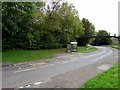
1
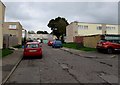
Marston Path, St Dials, Cwmbran
From Blenheim Road, Marston Path leads to Gileston Walk.
Image: © Jaggery
Taken: 20 Oct 2016
0.04 miles
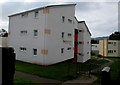
2
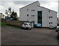
Cranham House, St Dials, Cwmbran
Social housing owned by Bron Afon Housing Association.
Image: © Jaggery
Taken: 20 Oct 2016
0.07 miles
3
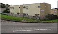
Elan Walk, St Dials, Cwmbran
Viewed across Blenheim Road.
Image: © Jaggery
Taken: 20 Oct 2016
0.07 miles
4
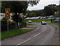
Warning signs facing Blenheim Road, St Dials, Cwmbran
On the approach to a bend in the road and a school.
Image: © Jaggery
Taken: 20 Oct 2016
0.08 miles
5
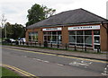
Guys 'n' Dolls in Blenheim Road, St Dials, Cwmbran
Unisex hairdressing salon next door to Blenheim Stores. http://www.geograph.org.uk/photo/5324342
Image: © Jaggery
Taken: 20 Oct 2016
0.08 miles
6
Blenheim Stores, Blenheim Road, St Dials, Cwmbran
Convenience store next door to Guys 'n' Dolls. http://www.geograph.org.uk/photo/5324334
Image: © Jaggery
Taken: 20 Oct 2016
0.08 miles
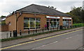
7
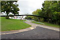
Footbridge over Blenheim Road, St Dials, Cwmbran
Viewed from the corner of the entrance road http://www.geograph.org.uk/photo/5324306 to Blenheim Road Community Primary School.
Image: © Jaggery
Taken: 20 Oct 2016
0.08 miles
8
Blenheim Road bus stop and shelter, St Dials, Cwmbran
Below the Tamarind. http://www.geograph.org.uk/photo/5166883
Image: © Jaggery
Taken: 20 Oct 2016
0.08 miles
9
Newchurch Court, St Dials, Cwmbran
Social housing owned by Bron Afon Housing Association.
Image: © Jaggery
Taken: 20 Oct 2016
0.08 miles
10
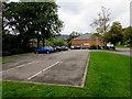
Private car park alongside Blenheim Road, St Dials, Cwmbran
The car park is for customers of the two shops http://www.geograph.org.uk/photo/5324342 ahead. Maximum stay two hours.
Image: © Jaggery
Taken: 20 Oct 2016
0.08 miles