IMAGES TAKEN NEAR TO
Blenheim Road, CWMBRAN, NP44 4NA
Introduction
This page details the photographs taken nearby to Blenheim Road, NP44 4NA by members of the Geograph project.
The Geograph project started in 2005 with the aim of publishing, organising and preserving representative images for every square kilometre of Great Britain, Ireland and the Isle of Man.

There are currently over 7.5m images from over14,400 individuals and you can help contribute to the project by visiting https://www.geograph.org.uk
Image Map
Images are licensed for reuse under creativecommons.org/licenses/by-sa/2.0
Notes
- Clicking on the map will re-center to the selected point.
- The higher the marker number, the further away the image location is from the centre of the postcode.
Image Listing (102 Images Found)
Images are licensed for reuse under creativecommons.org/licenses/by-sa/2.0
Image
Details
Distance
1

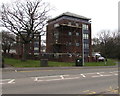
North side of Blenheim Court, St Dials, Cwmbran
One of two similar blocks of flats in Blenheim Court on the corner of Blenheim Road and Henllys Way.
The other block is 20 metres to the south of this one. http://www.geograph.org.uk/photo/1794586 to a wider view.
Image: © Jaggery
Taken: 20 Oct 2016
0.02 miles
2
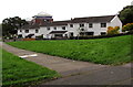
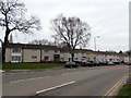
Row of houses, Blenheim Road, St Dials, Cwmbran
Set back from the west side of Blenheim Road. The top of Blenheim Court http://www.geograph.org.uk/photo/1794586 is in the background
Image: © Jaggery
Taken: 20 Oct 2016
0.02 miles
3
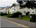
Telecoms cabinets near Blenheim Court, St Dials, Cwmbran
Two telecoms cabinets are on the Henllys Way side of two similar
blocks of flats in Blenheim Court on the corner of Blenheim Road.
Image: © Jaggery
Taken: 24 Mar 2018
0.02 miles
4
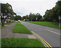
Southern end of Blenheim Road, Cwmbran
North along Blenheim Road from the corner of Henllys Way.
A nearby sign shows that Blenheim Road leads to Blenheim Square shops.
Image: © Jaggery
Taken: 20 Oct 2016
0.03 miles
5
Henllys Way telecoms cabinets, St Dials, Cwmbran
The BT cabinet on the right is near a Virgin Media cabinet.
Image: © Jaggery
Taken: 20 Oct 2016
0.04 miles
6
Houses and deciduous trees, Henllys Way, Cwmbran
Viewed in late March 2018.
Image: © Jaggery
Taken: 24 Mar 2018
0.04 miles
7
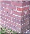
Ordnance Survey Cut Mark
This OS cut mark can be found on the SE angle of Blenheim Court, Henllys Way. It marks a point 78.751m above mean sea level.
Image: © Adrian Dust
Taken: 10 Sep 2020
0.04 miles
8
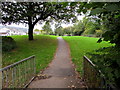
Path towards Shakespeare Road, Cwmbran
From the north side of Henllys Way.
Image: © Jaggery
Taken: 20 Oct 2016
0.04 miles
9
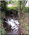
Dowlais Brook, Cwmbran
The brook emerges from the culvert under Blenheim Road.
Image: © Jaggery
Taken: 20 Oct 2016
0.04 miles
10
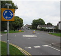
Mini-roundabout and sign, Henllys Way, Cwmbran
At the Blenheim Road junction.
Image: © Jaggery
Taken: 20 Oct 2016
0.05 miles