IMAGES TAKEN NEAR TO
Shelley Green, CWMBRAN, NP44 4LZ
Introduction
This page details the photographs taken nearby to Shelley Green, NP44 4LZ by members of the Geograph project.
The Geograph project started in 2005 with the aim of publishing, organising and preserving representative images for every square kilometre of Great Britain, Ireland and the Isle of Man.

There are currently over 7.5m images from over14,400 individuals and you can help contribute to the project by visiting https://www.geograph.org.uk
Image Map
Images are licensed for reuse under creativecommons.org/licenses/by-sa/2.0
Notes
- Clicking on the map will re-center to the selected point.
- The higher the marker number, the further away the image location is from the centre of the postcode.
Image Listing (138 Images Found)
Images are licensed for reuse under creativecommons.org/licenses/by-sa/2.0
Image
Details
Distance
1
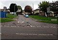
Shakespeare Road, St Dials, Cwmbran
The 30mph speed limit on Blenheim Road drops to 20mph along Shakespeare Road.
Image: © Jaggery
Taken: 20 Oct 2016
0.05 miles
2
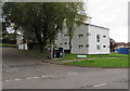
Norbury House, St Dials, Cwmbran
Flats on the corner of Blenheim Road and Amroth Walk.
Image: © Jaggery
Taken: 20 Oct 2016
0.06 miles
3
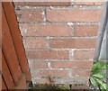
Ordnance Survey Cut Mark
This OS cut mark can be found on the garages on Shakespeare Road. It marks a point 83.704m above mean sea level.
Image: © Adrian Dust
Taken: 10 Sep 2020
0.07 miles
4
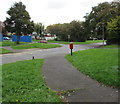
Path towards Blenheim Road, St Dials, Cwmbran
Behind Blenheim Road, the car is on the corner of Shakespeare Road.
Image: © Jaggery
Taken: 20 Oct 2016
0.07 miles
5
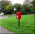
Queen Elizabeth II postbox, St Dials, Cwmbran
Located here. http://www.geograph.org.uk/photo/5324427
Image: © Jaggery
Taken: 20 Oct 2016
0.08 miles
6
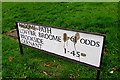
Bilingual name sign on a St Dials corner, Cwmbran
The sign shows BROOME PATH and BROOKSIDE and the Welsh LLWYBR BROOME and GERNANT.
No Welsh word for ODDS is shown.
Image: © Jaggery
Taken: 20 Oct 2016
0.08 miles
7
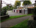
Brookside lockup garages, St Dials, Cwmbran
Near an area of houses on the northeast side of Dowlais Brook.
Image: © Jaggery
Taken: 20 Oct 2016
0.10 miles
8
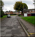
Patchy road surface, Brookside, St Dials, Cwmbran
Viewed from the corner of Blenheim Road in October 2016.
Image: © Jaggery
Taken: 20 Oct 2016
0.10 miles
9
Path towards Shakespeare Road, Cwmbran
From the north side of Henllys Way.
Image: © Jaggery
Taken: 20 Oct 2016
0.10 miles
10
Ysgol Gymraeg Nursery, St Dials, Cwmbran
The nursery building on the right is in the Ysgol Gymraeg site on the north side of Henllys Way. The school's website states that Ysgol Gymraeg Cwmbrân is a Welsh Primary School which was opened as an Infant and Junior School in September 1991 serving the catchment area of Cwmbran town and environs. In September 1997 a Nursery class was opened as part of the school. The school accepts pupils in accordance with the County Policy from the beginning of September following their fourth birthday or from the beginning of September following their third birthday to the nursery class.
I wondered why the English language part of the notice on the lamppost
is in UPPER CASE whereas the Welsh language text is in normal case.
Image: © Jaggery
Taken: 20 Oct 2016
0.11 miles