IMAGES TAKEN NEAR TO
Bowleaze, CWMBRAN, NP44 4LG
Introduction
This page details the photographs taken nearby to Bowleaze, NP44 4LG by members of the Geograph project.
The Geograph project started in 2005 with the aim of publishing, organising and preserving representative images for every square kilometre of Great Britain, Ireland and the Isle of Man.

There are currently over 7.5m images from over14,400 individuals and you can help contribute to the project by visiting https://www.geograph.org.uk
Image Map
Images are licensed for reuse under creativecommons.org/licenses/by-sa/2.0
Notes
- Clicking on the map will re-center to the selected point.
- The higher the marker number, the further away the image location is from the centre of the postcode.
Image Listing (96 Images Found)
Images are licensed for reuse under creativecommons.org/licenses/by-sa/2.0
Image
Details
Distance
1
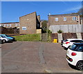
Bowleaze, Cwmbran
Bowleaze ascends from Ty Gwyn Road. Tesco Express http://www.geograph.org.uk/photo/4972597 is on the left.
Image: © Jaggery
Taken: 30 May 2016
0.04 miles
2
Junction of Archer Road and Ty Gwyn Road, Cwmbran
The northern end of the cul-de-sac Archer Road is here at the Ty Gwyn Road junction.
Image: © Jaggery
Taken: 30 May 2016
0.04 miles
3
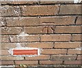
Ordnance Survey Cut Mark
This OS cut mark can be found on No165 Ecwleaze. It marks a point 132.050m above mean sea level.
Image: © Adrian Dust
Taken: 17 Aug 2020
0.04 miles
4
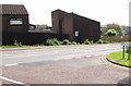
Tesco Express on a corner bank, Cwmbran
On top of the bank on the corner of Ty Gwyn Road and Bowleaze. Surprisingly for a town with a population of nearly 50,000, this is the only Tesco in Cwmbran in 2016. It opened here in 2009 in converted premises which were previously occupied by the Golden Harvest pub.
Usually located in a suburb, as here, a Tesco Express store has a very small selection of the range of items available in a Tesco Extra superstore.
Image: © Jaggery
Taken: 30 May 2016
0.05 miles
5
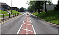
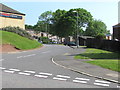
Down Ty Gwyn Road, Cwmbran
Ty Gwyn Road descends past the Ravenscourt junction http://www.geograph.org.uk/photo/5104814 out of shot on the right.
The car is at the Bowleaze junction. A Tesco Express http://www.geograph.org.uk/photo/5104809 is on a bank on the left.
Image: © Jaggery
Taken: 30 May 2016
0.05 miles
6
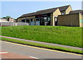
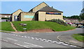
Tesco Express, Cwmbran
In 2009, Tesco converted a derelict building, formerly the Golden Harvest pub, into this Tesco Express store, above the corner of Ty Gwyn Road and Bowleaze. Usually located in a suburb, as here, a Tesco Express store has a very small selection of the range of items available in a Tesco Extra superstore.
Image: © Jaggery
Taken: 30 May 2016
0.05 miles
7

Bowleaze Court, Bowleaze name sign, Cwmbran
This part of Bowleaze is near Ty Gwyn Road and a Tesco Express http://www.geograph.org.uk/photo/5104809 on the site formerly occupied by the Golden Harvest pub.
Image: © Jaggery
Taken: 9 Apr 2017
0.05 miles
8
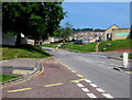
Rare example of a monolingual BUS STOP on a Cwmbran corner
On the corner of Archer Road and Ty Gwyn Road, only BUS STOP is painted on the road surface.
Most bus stops in Cwmbran also have the Welsh SAFLE BWS, as here. http://www.geograph.org.uk/photo/4972454
Image: © Jaggery
Taken: 30 May 2016
0.05 miles
9
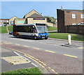
Sunday bus service on a Monday, Ty Gwyn Road, Cwmbran
A Sunday bus service is in operation in Cwmbran today, Spring Bank Holiday Monday May 30th 2016. Stagecoach Optare single-decker fleet number 47717 descends Ty Gwyn Road towards the town centre on bus route 6 from Ty Canol. Its frequency today is every 30 minutes. Some local services, such as route 2 Bus Station to and from Croesyceiliog do not operate on Sundays and thus not today.
Image: © Jaggery
Taken: 30 May 2016
0.05 miles
10
Steps up from Bowleaze towards Woolpitch, Cwmbran
Bowleaze and Woolpitch are residential areas between Ty Gwyn Road and Ty Gwyn Way.
Image: © Jaggery
Taken: 9 Apr 2017
0.06 miles