IMAGES TAKEN NEAR TO
Bowleaze, CWMBRAN, NP44 4LF
Introduction
This page details the photographs taken nearby to Bowleaze, NP44 4LF by members of the Geograph project.
The Geograph project started in 2005 with the aim of publishing, organising and preserving representative images for every square kilometre of Great Britain, Ireland and the Isle of Man.

There are currently over 7.5m images from over14,400 individuals and you can help contribute to the project by visiting https://www.geograph.org.uk
Image Map
Images are licensed for reuse under creativecommons.org/licenses/by-sa/2.0
Notes
- Clicking on the map will re-center to the selected point.
- The higher the marker number, the further away the image location is from the centre of the postcode.
Image Listing (103 Images Found)
Images are licensed for reuse under creativecommons.org/licenses/by-sa/2.0
Image
Details
Distance
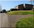
1
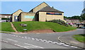
Entrance gate to Ty Gwyn allotments, Greenmeadow, Cwmbran
The entrance to the SE side of the allotments is from Ty Gwyn Way.
Image: © Jaggery
Taken: 30 Jan 2011
0.01 miles
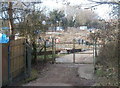
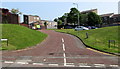
2
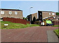
Steps up from Bowleaze towards Woolpitch, Cwmbran
Bowleaze and Woolpitch are residential areas between Ty Gwyn Road and Ty Gwyn Way.
Image: © Jaggery
Taken: 9 Apr 2017
0.02 miles
3

Bowleaze Court, Bowleaze name sign, Cwmbran
This part of Bowleaze is near Ty Gwyn Road and a Tesco Express http://www.geograph.org.uk/photo/5104809 on the site formerly occupied by the Golden Harvest pub.
Image: © Jaggery
Taken: 9 Apr 2017
0.04 miles
4
Bowleaze houses, Cwmbran
Bowleaze is an area of houses between Ty Gwyn Road and Ty Gwyn Way.
Image: © Jaggery
Taken: 9 Apr 2017
0.04 miles
5
Bowleaze, Cwmbran
Bowleaze ascends from Ty Gwyn Road. Tesco Express http://www.geograph.org.uk/photo/4972597 is on the left.
Image: © Jaggery
Taken: 30 May 2016
0.05 miles
6
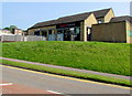
Tesco Express, Cwmbran
In 2009, Tesco converted a derelict building, formerly the Golden Harvest pub, into this Tesco Express store, above the corner of Ty Gwyn Road and Bowleaze. Usually located in a suburb, as here, a Tesco Express store has a very small selection of the range of items available in a Tesco Extra superstore.
Image: © Jaggery
Taken: 30 May 2016
0.05 miles
7
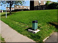
Former Pontnewydd litter bin in another area of Cwmbran
The inscription on this bin is 1989 PONTNEWYDD. The location of the bin in late May 2016 is at the edge of Ty Gwyn Road, opposite the Ravenscourt junction. The Pontnewydd area of Cwmbran is about a mile (1.6km) to the northeast. Neither the bin nor its base were here in a May 2011 Google Earth Street View.
Image: © Jaggery
Taken: 30 May 2016
0.05 miles
8
Tesco Express on a corner bank, Cwmbran
On top of the bank on the corner of Ty Gwyn Road and Bowleaze. Surprisingly for a town with a population of nearly 50,000, this is the only Tesco in Cwmbran in 2016. It opened here in 2009 in converted premises which were previously occupied by the Golden Harvest pub.
Usually located in a suburb, as here, a Tesco Express store has a very small selection of the range of items available in a Tesco Extra superstore.
Image: © Jaggery
Taken: 30 May 2016
0.06 miles
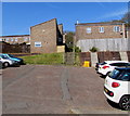
9
SSE van in Woolpitch, Cwmbran
Woolpitch is a cul-de-sac on the north side of Ty Gwyn Road in the Greenmeadow area of Cwmbran.
SSE is short for Scottish and Southern Energy.
Image: © Jaggery
Taken: 30 May 2016
0.06 miles
10
Woolpitch, Greenmeadow, Cwmbran
Woolpitch is a cul-de-sac on the north side of Ty Gwyn Road in the Greenmeadow area of Cwmbran.
An SSE (Scottish and Southern Energy) van http://www.geograph.org.uk/photo/4972335 is in the background.
Image: © Jaggery
Taken: 30 May 2016
0.06 miles