IMAGES TAKEN NEAR TO
Charston, CWMBRAN, NP44 4LD
Introduction
This page details the photographs taken nearby to Charston, NP44 4LD by members of the Geograph project.
The Geograph project started in 2005 with the aim of publishing, organising and preserving representative images for every square kilometre of Great Britain, Ireland and the Isle of Man.

There are currently over 7.5m images from over14,400 individuals and you can help contribute to the project by visiting https://www.geograph.org.uk
Image Map
Images are licensed for reuse under creativecommons.org/licenses/by-sa/2.0
Notes
- Clicking on the map will re-center to the selected point.
- The higher the marker number, the further away the image location is from the centre of the postcode.
Image Listing (96 Images Found)
Images are licensed for reuse under creativecommons.org/licenses/by-sa/2.0
Image
Details
Distance
1
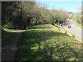
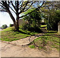
Path above Ty Gwyn Way, Cwmbran
The path leads to St Dials Road and Bowleaze.
Image: © Jaggery
Taken: 9 Apr 2017
0.05 miles
2
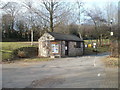
Entrance lodge, Greenmeadow Community Farm, Cwmbran
For visitors who have reached Cwmbran but are unsure of the community farm's exact location, the website states "just follow the brown signs with the white sheep and they will bring you to us".
The entrance is opposite a roundabout. http://www.geograph.org.uk/photo/2287115
Image: © Jaggery
Taken: 30 Jan 2011
0.06 miles
3
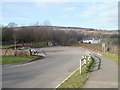
Entrance to Greenmeadow Community Farm, Cwmbran
The entrance is opposite the roundabout at the meeting of Ty Gwyn Way, Greenforge Way, St Dials Road and Greenmeadow Way.
Image: © Jaggery
Taken: 30 Jan 2011
0.06 miles
4
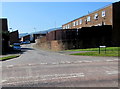
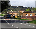
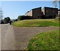
Charston, Greenmeadow, Cwmbran
Viewed across Greenmeadow Way. Charston is a cul-de-sac opposite Greenmeadow Surgery. http://www.geograph.org.uk/photo/5343689
Image: © Jaggery
Taken: 9 Apr 2017
0.07 miles
5
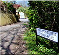
St Dials Road name sign, Cwmbran
The bilingual sign near the Bowleaze junction shows that St Dials Road is Heol Sain Derfel in Welsh.
Image: © Jaggery
Taken: 9 Apr 2017
0.07 miles
6
Charston, Greenmeadow, Cwmbran
Viewed across Greenmeadow Way, from the edge of the surgery. http://www.geograph.org.uk/photo/2289116
Annoyingly, Google repeatedly decided I really wanted to search for information on 'Charleston', but no, as the street name signs show, this is Charston.
Image: © Jaggery
Taken: 30 Jan 2011
0.08 miles
7
Stagecoach bus at a Ty Gwyn Road bus stop, Cwmbran
The bus is on Stagecoach Route 6 from Ty Canol towards Cwmbran bus station.
The Berthin junction is on the right.
Image: © Jaggery
Taken: 10 Oct 2016
0.08 miles
8
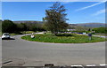
Roundabout at a major junction in Greenmeadow, Cwmbran
The 30 metres (about 100 ft) diameter roundabout is in the middle of
the junctions of Ty Gwyn Way, Greenforge Way, St Dials Road and Greenmeadow Way.
Image: © Jaggery
Taken: 9 Apr 2017
0.08 miles
9
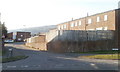
Bowleaze houses, Cwmbran
Bowleaze is an area of houses between Ty Gwyn Road and Ty Gwyn Way.
Image: © Jaggery
Taken: 9 Apr 2017
0.09 miles
10
Path to steps, Bowleaze, Cwmbran
Bowleaze is an area of houses between Ty Gwyn Road and Ty Gwyn Way.
Image: © Jaggery
Taken: 9 Apr 2017
0.09 miles