IMAGES TAKEN NEAR TO
Berthin, CWMBRAN, NP44 4LB
Introduction
This page details the photographs taken nearby to Berthin, NP44 4LB by members of the Geograph project.
The Geograph project started in 2005 with the aim of publishing, organising and preserving representative images for every square kilometre of Great Britain, Ireland and the Isle of Man.

There are currently over 7.5m images from over14,400 individuals and you can help contribute to the project by visiting https://www.geograph.org.uk
Image Map
Images are licensed for reuse under creativecommons.org/licenses/by-sa/2.0
Notes
- Clicking on the map will re-center to the selected point.
- The higher the marker number, the further away the image location is from the centre of the postcode.
Image Listing (101 Images Found)
Images are licensed for reuse under creativecommons.org/licenses/by-sa/2.0
Image
Details
Distance
1
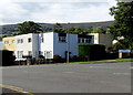
Charston, Greenmeadow, Cwmbran
Viewed across Greenmeadow Way, from the edge of the surgery. http://www.geograph.org.uk/photo/2289116
Annoyingly, Google repeatedly decided I really wanted to search for information on 'Charleston', but no, as the street name signs show, this is Charston.
Image: © Jaggery
Taken: 30 Jan 2011
0.04 miles
2
Stagecoach bus at a Ty Gwyn Road bus stop, Cwmbran
The bus is on Stagecoach Route 6 from Ty Canol towards Cwmbran bus station.
The Berthin junction is on the right.
Image: © Jaggery
Taken: 10 Oct 2016
0.04 miles
3
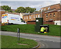
Adjusting the spaghetti in Cwmbran
An Openreach technician is working at a Ty Gwyn Road telecomms cabinet.
Openreach is the infrastructure division of the telecommunications company BT Group.
Whenever I see someone working on the wires and connections in a cabinet such as this,
I am amazed that they can make sense of what looks like a mass of coloured spaghetti to this observer...
Image: © Jaggery
Taken: 10 Oct 2016
0.04 miles
4
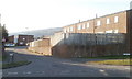
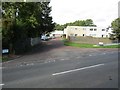
Junction of Fairhill and Ty Gwyn Road, Cwmbran
Extending for 800 metres from Fairwater Way, Fairhill ends here at the Ty Gwyn Road junction.
Image: © Jaggery
Taken: 10 Oct 2016
0.05 miles
5
Bilingual name sign Fairhill/Bryn Tirion, Cwmbran
The English/Welsh sign on the right faces the Ty Gwyn Road/Heol Ty Gwyn junction.
Moss Road housing is on the left.
Image: © Jaggery
Taken: 10 Oct 2016
0.05 miles
6
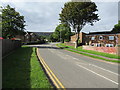
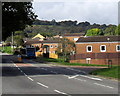
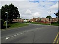
West along Ty Gwyn Road, Greenmeadow, Cwmbran
The left turns are into Thorncliffe Road and Fairhill.
Image: © Jaggery
Taken: 10 Oct 2016
0.05 miles
7
Charston, Greenmeadow, Cwmbran
Viewed across Greenmeadow Way. Charston is a cul-de-sac opposite Greenmeadow Surgery. http://www.geograph.org.uk/photo/5343689
Image: © Jaggery
Taken: 9 Apr 2017
0.06 miles
8
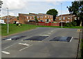
Three speed bumps across Fairhill, Greenmeadow, Cwmbran
Near the northeast end of Fairhill, on the approach to the Ty Gwyn Road junction.
Image: © Jaggery
Taken: 10 Oct 2016
0.07 miles
9
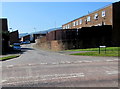
Moss Road, Greenmeadow, Cwmbran
Cul-de-sac on the north side of Fairhill.
Image: © Jaggery
Taken: 10 Oct 2016
0.07 miles
10
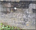
Ordnance Survey Cut Mark
This OS cut mark can be found on the wall of No1 Crofts Corner. It marks a point 114.880m above mean sea level.
Image: © Adrian Dust
Taken: 17 Aug 2020
0.07 miles