IMAGES TAKEN NEAR TO
Pandy, CWMBRAN, NP44 4LA
Introduction
This page details the photographs taken nearby to Pandy, NP44 4LA by members of the Geograph project.
The Geograph project started in 2005 with the aim of publishing, organising and preserving representative images for every square kilometre of Great Britain, Ireland and the Isle of Man.

There are currently over 7.5m images from over14,400 individuals and you can help contribute to the project by visiting https://www.geograph.org.uk
Image Map
Images are licensed for reuse under creativecommons.org/licenses/by-sa/2.0
Notes
- Clicking on the map will re-center to the selected point.
- The higher the marker number, the further away the image location is from the centre of the postcode.
Image Listing (103 Images Found)
Images are licensed for reuse under creativecommons.org/licenses/by-sa/2.0
Image
Details
Distance
1
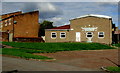
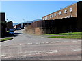
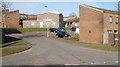
Greenmeadow and St Dials Community Hall, Cwmbran
Set back from the street named Pandy near the corner of Ty Gwyn Road.
The hall's Large Room (capacity 60 persons) and Small Room (40 persons) are available for hire.
Image: © Jaggery
Taken: 10 Oct 2016
0.01 miles
2
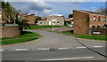
Junction of Ty Gwyn Road and Pandy, Greenmeadow, Cwmbran
The street named Pandy leads to Greenmeadow & St Dials Community Hall. http://www.geograph.org.uk/photo/5153661
Image: © Jaggery
Taken: 10 Oct 2016
0.02 miles
3
Charston, Greenmeadow, Cwmbran
Viewed across Greenmeadow Way, from the edge of the surgery. http://www.geograph.org.uk/photo/2289116
Annoyingly, Google repeatedly decided I really wanted to search for information on 'Charleston', but no, as the street name signs show, this is Charston.
Image: © Jaggery
Taken: 30 Jan 2011
0.03 miles
4
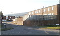
Towards a bend in Ty Gwyn Road, Cwmbran
Ty Gwyn Road between the Fairhill junction and the Thorncliffe Road junction on the right ahead.
Image: © Jaggery
Taken: 10 Oct 2016
0.04 miles
5
Charston, Greenmeadow, Cwmbran
Viewed across Greenmeadow Way. Charston is a cul-de-sac opposite Greenmeadow Surgery. http://www.geograph.org.uk/photo/5343689
Image: © Jaggery
Taken: 9 Apr 2017
0.05 miles
6
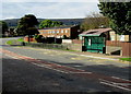
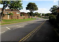
Ty Gwyn Road bus stop and shelter, Greenmeadow, Cwmbran
This side of the road for buses to Cwmbran bus station and the town centre.
Image: © Jaggery
Taken: 10 Oct 2016
0.05 miles
7
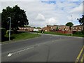
Junction of Fairhill and Ty Gwyn Road, Cwmbran
Extending for 800 metres from Fairwater Way, Fairhill ends here at the Ty Gwyn Road junction.
Image: © Jaggery
Taken: 10 Oct 2016
0.06 miles
8
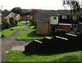
Steps down from Ty Gwyn Road, Greenmeadow, Cwmbran
Steps descend to a path past houses on the east side of Thorncliffe Road.
Image: © Jaggery
Taken: 10 Oct 2016
0.06 miles
9
Greenmeadow and St Dials Community Hall, Cwmbran
Viewed from Ty Gwyn Road. The community hall, the central building in the view, is
on a street named Pandy.
Image: © Jaggery
Taken: 30 Jan 2011
0.06 miles
10
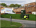
Adjusting the spaghetti in Cwmbran
An Openreach technician is working at a Ty Gwyn Road telecomms cabinet.
Openreach is the infrastructure division of the telecommunications company BT Group.
Whenever I see someone working on the wires and connections in a cabinet such as this,
I am amazed that they can make sense of what looks like a mass of coloured spaghetti to this observer...
Image: © Jaggery
Taken: 10 Oct 2016
0.06 miles