IMAGES TAKEN NEAR TO
Long Acre, CWMBRAN, NP44 4DY
Introduction
This page details the photographs taken nearby to Long Acre, NP44 4DY by members of the Geograph project.
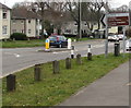
The Geograph project started in 2005 with the aim of publishing, organising and preserving representative images for every square kilometre of Great Britain, Ireland and the Isle of Man.

There are currently over 7.5m images from over14,400 individuals and you can help contribute to the project by visiting https://www.geograph.org.uk
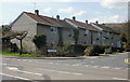
Image Map
Images are licensed for reuse under creativecommons.org/licenses/by-sa/2.0
Notes
- Clicking on the map will re-center to the selected point.
- The higher the marker number, the further away the image location is from the centre of the postcode.
Image Listing (77 Images Found)
Images are licensed for reuse under creativecommons.org/licenses/by-sa/2.0
Image
Details
Distance
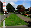
2
Housing on the west side on Henllys Way, Cwmbran
Viewed from the corner of Ton Road. Jule Road http://www.geograph.org.uk/photo/1794592 is in the background on the far left.
Image: © Jaggery
Taken: 24 Mar 2018
0.09 miles
3
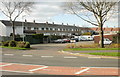
Court E, Fairwater, Cwmbran
This housing block, viewed from Fairwater Way, is Court E according to the name sign. It is shown without a name on the online Ordnance Survey map.
Image: © Jaggery
Taken: 8 Apr 2010
0.10 miles
4
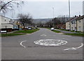
Henllys Way mini-roundabout opposite Fairwater Way, Cwmbran
Opposite the eastern end of Fairwater Way.
Image: © Jaggery
Taken: 24 Mar 2018
0.12 miles
5
Henllys Way direction and distances sign, Cwmbran
The sign alongside Henllys Way shows turn left into Fairwater Way https://www.geograph.org.uk/photo/5716938 for the Ty Canol
area of Cwmbran (1 mile) and Fairwater Leisure Centre (three-quarters of a mile).
Image: © Jaggery
Taken: 24 Mar 2018
0.13 miles
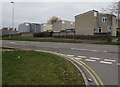
6
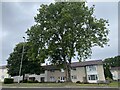
Windsor Road houses, Cwmbran
Houses on the west side of Windsor Road, viewed from Henllys Way.
Image: © Jaggery
Taken: 8 Apr 2010
0.13 miles
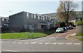
8
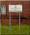
Primary School and Children's Centre nameboard, Cwmbran
The Nant Celyn Primary School and Cwmbran Integrated Children's Centre nameboard
faces Ton Road near these https://www.geograph.org.uk/photo/5716903 entrance gates. The text is also in Welsh.
Image: © Jaggery
Taken: 24 Mar 2018
0.13 miles
9
Cold Calling Control Zone notice, Fairwater, Cwmbran
The Trading Standards Notice faces Fairhill in the Fairwater area of Cwmbran.
See http://www.geograph.org.uk/photo/4325336 for another Cold Calling Control Zone in Torfaen and some details.
Image: © Jaggery
Taken: 10 Oct 2016
0.14 miles
10
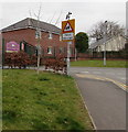
Warning sign - Patrol/Hebryngwr, Ton Road, Cwmbran
The English/Welsh sign is near the dark green entrance gates https://www.geograph.org.uk/photo/5716903 to Nant Celyn Primary School.
Image: © Jaggery
Taken: 24 Mar 2018
0.15 miles