IMAGES TAKEN NEAR TO
Warren Dale, CWMBRAN, NP44 4DB
Introduction
This page details the photographs taken nearby to Warren Dale, NP44 4DB by members of the Geograph project.
The Geograph project started in 2005 with the aim of publishing, organising and preserving representative images for every square kilometre of Great Britain, Ireland and the Isle of Man.

There are currently over 7.5m images from over14,400 individuals and you can help contribute to the project by visiting https://www.geograph.org.uk
Image Map
Images are licensed for reuse under creativecommons.org/licenses/by-sa/2.0
Notes
- Clicking on the map will re-center to the selected point.
- The higher the marker number, the further away the image location is from the centre of the postcode.
Image Listing (52 Images Found)
Images are licensed for reuse under creativecommons.org/licenses/by-sa/2.0
Image
Details
Distance
1
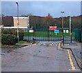
School entrance gates, Coed Eva, Cwmbran
This entrance to Coed Eva Primary School is at the western end of the road named Teynes.
Image: © Jaggery
Taken: 31 Dec 2023
0.07 miles
2
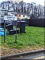
COURT B Teynes 4-16 name sign on grass, Coed Eva, Cwmbran
Alongside the road named Teynes. The entrance https://www.geograph.org.uk/photo/7680347 to Coed Eva Primary School is behind the camera.
Image: © Jaggery
Taken: 31 Dec 2023
0.11 miles
3
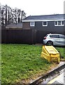
Yellow on green, Teynes, Coed Eva, Cwmbran
The yellow box containing grit is alongside the road named Teynes.
The entrance https://www.geograph.org.uk/photo/7680347 to Coed Eva Primary School is behind the camera.
Image: © Jaggery
Taken: 31 Dec 2023
0.11 miles
4
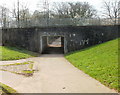
Underpass, Henllys Way, Coed Eva
A pedestrian underpass beneath Henllys Way, viewed from the east side. Nearby on the other side of the underpass is Rede Road.
Image: © Jaggery
Taken: 8 Apr 2010
0.12 miles
5
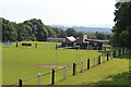
Sports pitches, Penylan Way, Cwmbran
Cwmbran Town Football Club ground.
Image: © M J Roscoe
Taken: 21 Jul 2021
0.13 miles
6
Deciduous trees in winter, Coed Eva, Cwmbran
Leafless trees viewed from Henllys Way on December 31st 2023.
Image: © Jaggery
Taken: 31 Dec 2023
0.13 miles
7
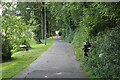
The Incline below Penylan Way
Cycle and pedestrian path on the site of a former tramway down from Henllys Colliery.
Image: © M J Roscoe
Taken: 21 Jul 2021
0.14 miles
8
The Fairwater House, Cwmbran
Pub on the corner of Fairwater Way and Fairhill.
Image: © Jaggery
Taken: 8 Apr 2010
0.15 miles
9

Telecoms mast and cabinets, Fairwater, Cwmbran
Recently installed mast viewed in November 2021.
An older mast https://www.geograph.org.uk/photo/5149531 is near the camera.
Image: © Jaggery
Taken: 14 Nov 2021
0.16 miles
10
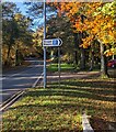
Direction sign alongside Fairwater Way, Cwmbran
Turn right here for a free car park near shops and Fairwater Post Office. Siopau is Welsh for Shops.
Image: © Jaggery
Taken: 14 Nov 2021
0.16 miles