IMAGES TAKEN NEAR TO
St. Dials Road, CWMBRAN, NP44 4BQ
Introduction
This page details the photographs taken nearby to St. Dials Road, NP44 4BQ by members of the Geograph project.
The Geograph project started in 2005 with the aim of publishing, organising and preserving representative images for every square kilometre of Great Britain, Ireland and the Isle of Man.

There are currently over 7.5m images from over14,400 individuals and you can help contribute to the project by visiting https://www.geograph.org.uk
Image Map
Images are licensed for reuse under creativecommons.org/licenses/by-sa/2.0
Notes
- Clicking on the map will re-center to the selected point.
- The higher the marker number, the further away the image location is from the centre of the postcode.
Image Listing (93 Images Found)
Images are licensed for reuse under creativecommons.org/licenses/by-sa/2.0
Image
Details
Distance
1
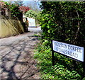
St Dials Road name sign, Cwmbran
The bilingual sign near the Bowleaze junction shows that St Dials Road is Heol Sain Derfel in Welsh.
Image: © Jaggery
Taken: 9 Apr 2017
0.02 miles
2
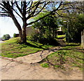
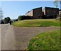
Path to steps, Bowleaze, Cwmbran
Bowleaze is an area of houses between Ty Gwyn Road and Ty Gwyn Way.
Image: © Jaggery
Taken: 9 Apr 2017
0.04 miles
3
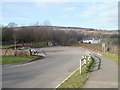
Entrance to Greenmeadow Community Farm, Cwmbran
The entrance is opposite the roundabout at the meeting of Ty Gwyn Way, Greenforge Way, St Dials Road and Greenmeadow Way.
Image: © Jaggery
Taken: 30 Jan 2011
0.05 miles
4
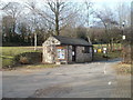
Entrance lodge, Greenmeadow Community Farm, Cwmbran
For visitors who have reached Cwmbran but are unsure of the community farm's exact location, the website states "just follow the brown signs with the white sheep and they will bring you to us".
The entrance is opposite a roundabout. http://www.geograph.org.uk/photo/2287115
Image: © Jaggery
Taken: 30 Jan 2011
0.05 miles
5
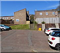
Bowleaze houses, Cwmbran
Bowleaze is an area of houses between Ty Gwyn Road and Ty Gwyn Way.
Image: © Jaggery
Taken: 9 Apr 2017
0.05 miles
6
Steps up from Bowleaze towards Woolpitch, Cwmbran
Bowleaze and Woolpitch are residential areas between Ty Gwyn Road and Ty Gwyn Way.
Image: © Jaggery
Taken: 9 Apr 2017
0.07 miles
7
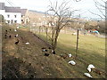
Ducks and geese, Greenmeadow Community Farm, Cwmbran
A small sample of the animals at the farm. http://www.geograph.org.uk/photo/2287139
There are various breeds of cattle, pigs, sheep and goats. Among the other animals are alpacas, bantams, chickens, chinchillas, deer, donkeys, doves, ferrets, guinea pigs, llamas and rabbits.
Image: © Jaggery
Taken: 30 Jan 2011
0.07 miles
8
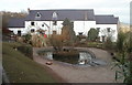
Farmhouse, Greenmeadow Community Farm, Cwmbran
The farmhouse, dating from 1752, is built from local Welsh stone with a Welsh slate roof. Greenmeadow Farm had been a working farm for more than two centuries when it was bought by a group of local people c1980. They turned it into a Community Farm to ensure that it would remain a green space for Cwmbran.
Image: © Jaggery
Taken: 30 Jan 2011
0.07 miles
9
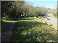
Path above Ty Gwyn Way, Cwmbran
The path leads to St Dials Road and Bowleaze.
Image: © Jaggery
Taken: 9 Apr 2017
0.07 miles
10
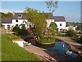
Duck pond and farmhouse, Greenmeadow Farm
Image: © Robin Drayton
Taken: 30 Sep 2015
0.08 miles