IMAGES TAKEN NEAR TO
Michael Thacker Court, CWMBRAN, NP44 4AF
Introduction
This page details the photographs taken nearby to Michael Thacker Court, NP44 4AF by members of the Geograph project.
The Geograph project started in 2005 with the aim of publishing, organising and preserving representative images for every square kilometre of Great Britain, Ireland and the Isle of Man.

There are currently over 7.5m images from over14,400 individuals and you can help contribute to the project by visiting https://www.geograph.org.uk
Image Map
Images are licensed for reuse under creativecommons.org/licenses/by-sa/2.0
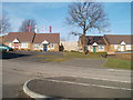
Notes
- Clicking on the map will re-center to the selected point.
- The higher the marker number, the further away the image location is from the centre of the postcode.
Image Listing (102 Images Found)
Images are licensed for reuse under creativecommons.org/licenses/by-sa/2.0
Image
Details
Distance
1
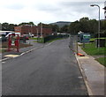
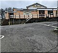
Entrance to Blenheim Road Community Primary School, Cwmbran
From the west side of Blenheim Road.
Image: © Jaggery
Taken: 20 Oct 2016
0.01 miles
2
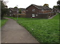
Broom Path, St Dials, Cwmbran
Houses between Blenheim Road and Brookside.
Image: © Jaggery
Taken: 20 Oct 2016
0.06 miles
3
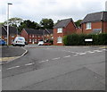
Houses at the southeast end of Thorncliffe Road, Cwmbran
Above Blenheim Road, near the Tamarind. http://www.geograph.org.uk/photo/5166883
Image: © Jaggery
Taken: 20 Oct 2016
0.06 miles
4
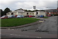
Tamarind restaurant and bar, St Dials, Cwmbran
Indian cuisine restaurant located in the former Marlborough pub above Blenheim Road.
Image: © Jaggery
Taken: 20 Oct 2016
0.06 miles
5
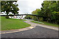
Footbridge over Blenheim Road, St Dials, Cwmbran
Viewed from the corner of the entrance road http://www.geograph.org.uk/photo/5324306 to Blenheim Road Community Primary School.
Image: © Jaggery
Taken: 20 Oct 2016
0.07 miles
6
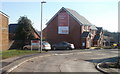
Tamarind, St Dials, Cwmbran
Viewed from Blenheim Road in April 2024. A board on the wall shows
"TAMARIND
RESTAURANT
& BAR
Contemporary Indian Cuisine
at its Finest"
Image: © Jaggery
Taken: 7 Apr 2024
0.07 miles
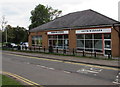
7
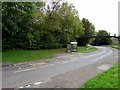
Blenheim Road bus stop and shelter, St Dials, Cwmbran
Below the Tamarind. http://www.geograph.org.uk/photo/5166883
Image: © Jaggery
Taken: 20 Oct 2016
0.07 miles
8
Northern edge of Blenheim Chase, St Dials. Fairwater
Blenheim Chase is a Lovell development of 1- 2- and 3-bedroom houses adjoining Cresswell Walk (at the left edge of the view), on the southern side of Ty Gwyn Road.
Image: © Jaggery
Taken: 30 Jan 2011
0.09 miles
9
Bungalows, Blenheim Chase, St Dials, Cwmbran
Blenheim Chase is a Lovell development of 1- 2- and 3-bedroom houses adjoining Cresswell Walk, on the southern side of Ty Gwyn Road.
Image: © Jaggery
Taken: 30 Jan 2011
0.09 miles
10
Guys 'n' Dolls in Blenheim Road, St Dials, Cwmbran
Unisex hairdressing salon next door to Blenheim Stores. http://www.geograph.org.uk/photo/5324342
Image: © Jaggery
Taken: 20 Oct 2016
0.09 miles