IMAGES TAKEN NEAR TO
Henllys Way, CWMBRAN, NP44 3YS
Introduction
This page details the photographs taken nearby to Henllys Way, NP44 3YS by members of the Geograph project.
The Geograph project started in 2005 with the aim of publishing, organising and preserving representative images for every square kilometre of Great Britain, Ireland and the Isle of Man.

There are currently over 7.5m images from over14,400 individuals and you can help contribute to the project by visiting https://www.geograph.org.uk
Image Map
Images are licensed for reuse under creativecommons.org/licenses/by-sa/2.0
Notes
- Clicking on the map will re-center to the selected point.
- The higher the marker number, the further away the image location is from the centre of the postcode.
Image Listing (181 Images Found)
Images are licensed for reuse under creativecommons.org/licenses/by-sa/2.0
Image
Details
Distance
1
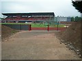
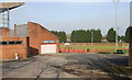
Cwmbran Stadium
Home ground of Cwmbran Town F.C. and athletics stadium.
Image: © David Luther Thomas
Taken: 16 Sep 2006
0.04 miles
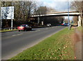
2
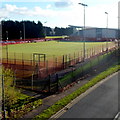
Cwmbran Stadium viewed from Henllys Way
Viewed from this bridge http://www.geograph.org.uk/photo/3249067 carrying Henllys Way over Cwmbran Drive.
Image: © Jaggery
Taken: 1 Dec 2012
0.04 miles
3
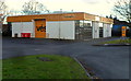
Telev?s, Cwmbran
Located in Unit 11, Hill Street Industrial Estate. Their website describes Televés as a
"leading global company focused in the design, development and manufacture of equipment for distributing telecommunication services throughout the infrastructures of buildings and homes"
The company has its HQ in Santiago de Compostela (Spain), where it has its state-of-the-art manufacturing facilities.
Image: © Jaggery
Taken: 1 Dec 2012
0.06 miles
4
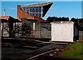
Electricity substation at the edge of Cwmbran Stadium
The Western Power Distribution electricity substation identifier is
OAKFIELD RD CWMBRAN S/S No. 532241.
Image: © Jaggery
Taken: 7 Dec 2014
0.06 miles
5
A glimpse of Cwmbran Stadium's football pitch
Viewed from the southwest edge of the stadium, adjacent to Oakfield Road.
Image: © Jaggery
Taken: 6 Feb 2010
0.06 miles
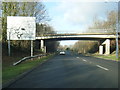
6
Cwmbran Drive approaches the Stadium double roundabouts
Viewed from the footpath on the east side of Cwmbran Drive near the Llandowlais Street / Oakfield Road bridge. A large sign on the left show a double roundabout ahead, at the junction for Cwmbran Stadium.
Much of Cwmbran Drive, as here, is along the trackbed of a dismantled railway.
Image: © Jaggery
Taken: 1 Dec 2012
0.07 miles
7
Cwmbran Drive passes under Heol Oakfield
Image: © Colin Pyle
Taken: 17 Dec 2013
0.07 miles
8
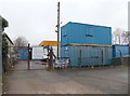
Galboola Ltd, Cwmbran
Located at the far end of Tranquil Place, on the north side of Llandowlais Street.
Galboola's business is building and civil engineering contractors.
Image: © Jaggery
Taken: 9 Mar 2013
0.07 miles
9
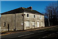
House on the corner of Tranquil Place and Llandowlais Street, Cwmbran
In December 2014, this large corner house has a derelict appearance.
Image: © Jaggery
Taken: 7 Dec 2014
0.07 miles
10
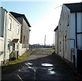
Tranquil Place, Cwmbran
Tranquil Place is a short dead-end street, viewed looking south towards Llandowlais Place.
Galboola http://www.geograph.org.uk/photo/3365525 is behind the camera.
Image: © Jaggery
Taken: 7 Dec 2014
0.07 miles