IMAGES TAKEN NEAR TO
The Tower, CWMBRAN, NP44 3QZ
Introduction
This page details the photographs taken nearby to The Tower, NP44 3QZ by members of the Geograph project.
The Geograph project started in 2005 with the aim of publishing, organising and preserving representative images for every square kilometre of Great Britain, Ireland and the Isle of Man.

There are currently over 7.5m images from over14,400 individuals and you can help contribute to the project by visiting https://www.geograph.org.uk
Image Map
Images are licensed for reuse under creativecommons.org/licenses/by-sa/2.0
Notes
- Clicking on the map will re-center to the selected point.
- The higher the marker number, the further away the image location is from the centre of the postcode.
Image Listing (630 Images Found)
Images are licensed for reuse under creativecommons.org/licenses/by-sa/2.0
Image
Details
Distance
1
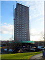
Exterior renovation of The Tower, Cwmbran
This early December 2012 view shows work in progress on a 37-week refurbishment of Cwmbran's tallest building, The Tower. http://www.geograph.org.uk/photo/1611824 Seddon Construction are doing the work for the building's owners, Bron Afon Community Housing. The £997,000 refurbishment programme includes overcladding, installation of replacement windows, reroofing work, reconstruction of the main entrance area and the redecoration of external communal areas.
Image: © Jaggery
Taken: 4 Dec 2012
0.00 miles
2
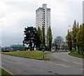
Trees dwarfed by the Tower Block, Cwmbran
Viewed across St David's Road.
Built in 1967, the 22-storey block of flats is 64 metres (210 ft) high, the tallest building in Cwmbran.
Image: © Jaggery
Taken: 14 Apr 2017
0.00 miles
3
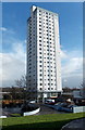
White tower block in Cwmbran
Viewed in late January 2014. http://www.geograph.org.uk/photo/3251843 to an earlier view of The Tower
during renovation work. The white exterior is a big improvement
on its earlier bleak appearance. http://www.geograph.org.uk/photo/1611824
Image: © Jaggery
Taken: 27 Jan 2014
0.01 miles
4
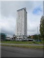
The Tower Block, Southville, Cwmbran
At 64 metres (210 feet), this is Cwmbran's tallest building, currently owned by Bron Afon Housing Association.
Image: © Jaggery
Taken: 14 Apr 2017
0.01 miles
5
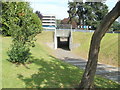
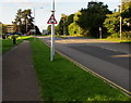
Pedestrian underpass near Cwmbran shopping centre
A path passes under the southern edge of the St Davids Road / Tudor Road roundabout near the SE edge of Cwmbran shopping centre. A shopping centre multi-storey car park (free) is in the background.
Image: © Jaggery
Taken: 2 Sep 2011
0.02 miles
6
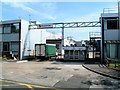
Entrance gate to Meritor, Cwmbran
Viewed across Grange Road. Meritor produce braking systems for heavy vehicles.
Image: © Jaggery
Taken: 2 Sep 2011
0.02 miles
7
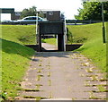
One footpath underpass viewed from another, Cwmbran
Viewed from this http://www.geograph.org.uk/photo/3053763 underpass. Both underpasses are inside a roundabout at the junction of St David's Road and Tudor Road.
Image: © Jaggery
Taken: 26 Jul 2012
0.02 miles
8
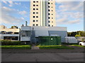
Gas installation, Redbrook Way, Cwmbran
The dark green cabinet is a Wales & West Utilities gas installation.
Its identifier is TOWER BLOCK DG, REDBROOK HOUSE, CWMBRAN.
The Tower Block http://www.geograph.org.uk/photo/3828457 is in the background.
Image: © Jaggery
Taken: 5 Oct 2016
0.02 miles
9
Pavement below St David's Road, Cwmbran
Slightly below road level, the pavement descends towards an underpass on the west side of the roundabout ahead.
Image: © Jaggery
Taken: 5 Oct 2016
0.02 miles
10
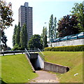
Underpass and a view of The Tower Block, Cwmbran
A footpath on the side of St David's Road enters an underpass beneath the roadway.
Ahead is the 64 metre (210ft) high Tower Block. http://www.geograph.org.uk/photo/1611824
Image: © Jaggery
Taken: 26 Jul 2012
0.03 miles