IMAGES TAKEN NEAR TO
Radnor Way, CWMBRAN, NP44 3QX
Introduction
This page details the photographs taken nearby to Radnor Way, NP44 3QX by members of the Geograph project.
The Geograph project started in 2005 with the aim of publishing, organising and preserving representative images for every square kilometre of Great Britain, Ireland and the Isle of Man.

There are currently over 7.5m images from over14,400 individuals and you can help contribute to the project by visiting https://www.geograph.org.uk
Image Map
Images are licensed for reuse under creativecommons.org/licenses/by-sa/2.0
Notes
- Clicking on the map will re-center to the selected point.
- The higher the marker number, the further away the image location is from the centre of the postcode.
Image Listing (567 Images Found)
Images are licensed for reuse under creativecommons.org/licenses/by-sa/2.0
Image
Details
Distance
1
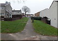
Towards Wentloog Close, Cwmbran
A view from Llywelyn Road looking towards Wentloog Close and Radnor Way.
Image: © Jaggery
Taken: 20 Feb 2013
0.01 miles
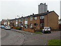
2
West side of Radnor Way, Cwmbran
Viewed from the corner of Redbrook Way looking towards Wentloog Close.
Image: © Jaggery
Taken: 3 Feb 2014
0.02 miles
3
Northern end of Radnor Place, Cwmbran
A view north in the direction of Tudor Road. The houses are on the east side of Radnor Place.
The Tower Block http://www.geograph.org.uk/photo/1611824 is in the background.
Image: © Jaggery
Taken: 20 Feb 2013
0.02 miles
4
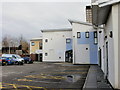
Cwmbran Clinic
Cwmbran Clinic (Canolfan Ty Newydd) is located between Tudor Road and Radnor Way. It is immediately behind the magistrates court, and is accessed by the narrow road that goes between the magistrates court and the police station.
An edge of The Tower Block http://www.geograph.org.uk/photo/1611824 can be seen at the upper right.
Image: © Jaggery
Taken: 31 Dec 2009
0.03 miles
5
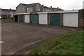
Zigzag pattern of locks on Redbrook Way garages, Cwmbran
The alternating low and high positions of the locks on adjacent garages form a zigzag pattern.
Image: © Jaggery
Taken: 3 Feb 2014
0.03 miles
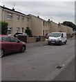
6
South along Radnor Way, Southville, Cwmbran
Looking past the Redbrook Way junction http://www.geograph.org.uk/photo/5507149 on the left.
Image: © Jaggery
Taken: 11 Aug 2017
0.03 miles
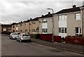
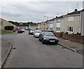
7
East side of Radnor Way, Southville, Cwmbran
The houses are between Redbrook Way (behind the camera) and Whitebrook Way.
Image: © Jaggery
Taken: 11 Aug 2017
0.03 miles
8
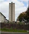
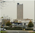
The Tower Block, Cwmbran
The imaginative name is a clue that this is Cwmbran's only skyscraper, and thus its tallest building (210 feet or 64 metres). Located in Southville, close to the southeast edge of Cwmbran Shopping Centre. It was built for two main reasons - as a landmark building, and to mask two chimney stacks which removed fumes from boilers that heated water used by the shopping centre.
When completed in 1967, it was the tallest building in Wales. It has 22 storeys. There are 81 flats - 20 two bedroom, 40 one bedroom, 20 bed sitters and the caretaker's flat. Parking is underneath the building.
Image: © Jaggery
Taken: 17 Oct 2009
0.04 miles
9
Cwmbran Tower Block viewed from Llewellyn Road
The Tower Block, http://www.geograph.org.uk/photo/1611824, Cwmbran's only skyscraper, can be seen in much of the town. Here, it is viewed from Llewellyn Road.
Image: © Jaggery
Taken: 15 Oct 2009
0.04 miles
10
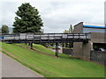
Wooden footbridge to The Tower Block, Cwmbran
From a footpath a few metres north of Redbrook Way, a wooden footbridge leads to The Tower Block. http://www.geograph.org.uk/photo/1611824
Image: © Jaggery
Taken: 30 Aug 2011
0.04 miles