IMAGES TAKEN NEAR TO
Redbrook Way, CWMBRAN, NP44 3QT
Introduction
This page details the photographs taken nearby to Redbrook Way, NP44 3QT by members of the Geograph project.
The Geograph project started in 2005 with the aim of publishing, organising and preserving representative images for every square kilometre of Great Britain, Ireland and the Isle of Man.

There are currently over 7.5m images from over14,400 individuals and you can help contribute to the project by visiting https://www.geograph.org.uk
Image Map
Images are licensed for reuse under creativecommons.org/licenses/by-sa/2.0
Notes
- Clicking on the map will re-center to the selected point.
- The higher the marker number, the further away the image location is from the centre of the postcode.
Image Listing (412 Images Found)
Images are licensed for reuse under creativecommons.org/licenses/by-sa/2.0
Image
Details
Distance
1
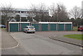
7 lockup-garages, Redbrook Way, Cwmbran
The garages are at the eastern end of Redbrook Way, at the edge of St David's Road.
Image: © Jaggery
Taken: 20 Feb 2013
0.01 miles
2
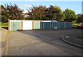
Lockup garages, Redbrook Way, Cwmbran
On October 5th 2016 there are two abandoned supermarket shopping trolleys
alongside one of seven lockup garages at the eastern end of Redbrook Way.
Image: © Jaggery
Taken: 5 Oct 2016
0.01 miles
3
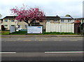
Pink blossom, St David's Road, Southville, Cwmbran
Viewed on Good Friday April 14th 2017.
Image: © Jaggery
Taken: 14 Apr 2017
0.01 miles
4
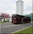
Megabus Gold sleeper coach, St David's Road, Southville, Cwmbran
In April 2017, the 3-axle Van Hool coach is travelling towards Cwmbran bus station.
The Tower Block is in the background.https://www.geograph.org.uk/photo/5689719
Image: © Jaggery
Taken: 14 Apr 2017
0.02 miles
5
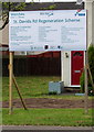
St David's Road Regeneration Scheme information board, Southville, Cwmbran
On the right here https://www.geograph.org.uk/photo/5689763 viewed in April 2017.
Image: © Jaggery
Taken: 14 Apr 2017
0.02 miles
6
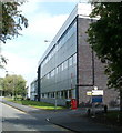
Former Lufthansa Resource Technical Training, Cwmbran
Located on Grange Road. The building formerly housed the Resource Technical Training facilities of Lufthansa, the German airline. The Lufthansa website states that the training facilities relocated to Cotswold Airport, Cirencester in June 2010.
Image: © Jaggery
Taken: 2 Sep 2011
0.02 miles
7
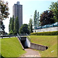
Underpass and a view of The Tower Block, Cwmbran
A footpath on the side of St David's Road enters an underpass beneath the roadway.
Ahead is the 64 metre (210ft) high Tower Block. http://www.geograph.org.uk/photo/1611824
Image: © Jaggery
Taken: 26 Jul 2012
0.02 miles
8
St David's Road Regeneration Scheme, Southville, Cwmbran
Viewed in April 2017. A nearby board https://www.geograph.org.uk/photo/5689766 shows that the principal contractor is Westdale Services Ltd, Kelvedon Business Centre, Newport. Principal designer is Construction Safety Planning Ltd, Cyfarthfa Mews, Clwydyfagwr, Merthyr Tydfil. The client is the Senior Contracts Manager, Bron Afon Community Housing.
Image: © Jaggery
Taken: 14 Apr 2017
0.02 miles
9
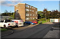
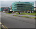
Redbrook House, Redbrook Way, Southville, Cwmbran
Redbrook House is a four-storey block of flats on the corner of St David's Road.
Image: © Jaggery
Taken: 5 Oct 2016
0.02 miles
10
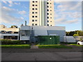
Gas installation, Redbrook Way, Cwmbran
The dark green cabinet is a Wales & West Utilities gas installation.
Its identifier is TOWER BLOCK DG, REDBROOK HOUSE, CWMBRAN.
The Tower Block http://www.geograph.org.uk/photo/3828457 is in the background.
Image: © Jaggery
Taken: 5 Oct 2016
0.02 miles