IMAGES TAKEN NEAR TO
Newgale Row, CWMBRAN, NP44 3QJ
Introduction
This page details the photographs taken nearby to Newgale Row, NP44 3QJ by members of the Geograph project.
The Geograph project started in 2005 with the aim of publishing, organising and preserving representative images for every square kilometre of Great Britain, Ireland and the Isle of Man.

There are currently over 7.5m images from over14,400 individuals and you can help contribute to the project by visiting https://www.geograph.org.uk
Image Map
Images are licensed for reuse under creativecommons.org/licenses/by-sa/2.0
Notes
- Clicking on the map will re-center to the selected point.
- The higher the marker number, the further away the image location is from the centre of the postcode.
Image Listing (386 Images Found)
Images are licensed for reuse under creativecommons.org/licenses/by-sa/2.0
Image
Details
Distance
1
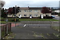
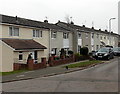
Row of three houses, Southville, Cwmbran
Set back from the corner of St David's Road and Newgale Row.
Image: © Jaggery
Taken: 14 Apr 2017
0.00 miles
2
Encased housing, Southville, Cwmbran
Work is in progress on the St David's Road Regeneration Scheme, viewed in April 2017.
Image: © Jaggery
Taken: 14 Apr 2017
0.02 miles
3
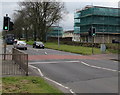
Pelican crossing, St David's Road, Southville, Cwmbran
Chambers Dictionary states that pelican in this context is adapted from "pedestrian light controlled crossing".
Image: © Jaggery
Taken: 14 Apr 2017
0.02 miles
4
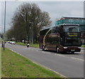
Megabus Gold coach in Southville, Cwmbran
The 12.9 litre 3-axle Van Hool coach on St David's Road is travelling towards Cwmbran bus station.
The coach is part of the Megabus Gold sleeper service https://www.geograph.org.uk/photo/5689829 viewed in April 2017.
Image: © Jaggery
Taken: 14 Apr 2017
0.02 miles
5
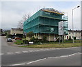
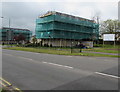
Scaffolding on Newgale House, Southville, Cwmbran
On the corner of Newgale Row and St David's Road, viewed in April 2017.
Newgale House is being refurbished during the St David's Road housing regeneration scheme.
Image: © Jaggery
Taken: 14 Apr 2017
0.02 miles
6
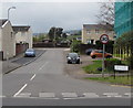
St Arvans Road, Cwmbran
South along St Arvans Road from Redbrook Way.
Image: © Jaggery
Taken: 5 Oct 2016
0.03 miles
7
East side of St Arvans Road, Cwmbran
Viewed from Redbrook Way. http://www.geograph.org.uk/photo/3340836 to a view of the west side of St Arvans Road.
Image: © Jaggery
Taken: 20 Feb 2013
0.03 miles
8
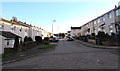
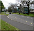
West along Newgale Row, Southville, Cwmbran
From St David's Road along Newgale Row towards St Arvans Road. The 40mph speed limit drops to 30mph.
Image: © Jaggery
Taken: 14 Apr 2017
0.03 miles
9
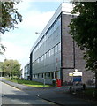
Former Lufthansa Resource Technical Training, Cwmbran
Located on Grange Road. The building formerly housed the Resource Technical Training facilities of Lufthansa, the German airline. The Lufthansa website states that the training facilities relocated to Cotswold Airport, Cirencester in June 2010.
Image: © Jaggery
Taken: 2 Sep 2011
0.03 miles
10
Goldcliff House bus stop, Southville, Cwmbran
This stop is on the X24 bus route to Market Square bus station in Newport city centre. Viewed in April 2017.
Image: © Jaggery
Taken: 14 Apr 2017
0.03 miles