IMAGES TAKEN NEAR TO
Whitebrook Way, CWMBRAN, NP44 3PX
Introduction
This page details the photographs taken nearby to Whitebrook Way, NP44 3PX by members of the Geograph project.
The Geograph project started in 2005 with the aim of publishing, organising and preserving representative images for every square kilometre of Great Britain, Ireland and the Isle of Man.

There are currently over 7.5m images from over14,400 individuals and you can help contribute to the project by visiting https://www.geograph.org.uk
Image Map
Images are licensed for reuse under creativecommons.org/licenses/by-sa/2.0
Notes
- Clicking on the map will re-center to the selected point.
- The higher the marker number, the further away the image location is from the centre of the postcode.
Image Listing (481 Images Found)
Images are licensed for reuse under creativecommons.org/licenses/by-sa/2.0
Image
Details
Distance
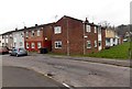
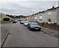
1
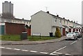
Whitebrook Way houses, Cwmbran
Houses on the north side of Whitebrook Way, viewed from Radnor Road.
The Tower Block http://www.geograph.org.uk/photo/1611824 is in the background.
Image: © Jaggery
Taken: 20 Feb 2013
0.02 miles
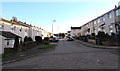
2
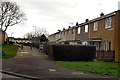
Llandenny Walk, Cwmbran
Looking east from Radnor Way.
Image: © Jaggery
Taken: 3 Feb 2014
0.05 miles
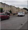
3
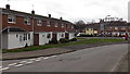
Houses at the southern end of Radnor Way, Cwmbran
The house are between the Whitebrook Way junction on the left and Llywelyn Road.
Image: © Jaggery
Taken: 3 Feb 2014
0.05 miles
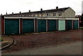
4
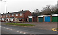
Houses and lockup garages, Llywelyn Road, Cwmbran
This part of Llywelyn Road is opposite Radnor Way.
Image: © Jaggery
Taken: 20 Feb 2013
0.06 miles
5
Individualistic statement in Cwmbran
Six very similar lock-up garages and one nonconformist located alongside Radnor Way.
Image: © Jaggery
Taken: 3 Feb 2014
0.06 miles
6
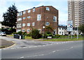
Newgale House, Newgale Row, Cwmbran
Located on the corner of Newgale Row and St David's Road, Newgale House contains 8 flats.
The four-storey building is dwarfed by the 22-storey The Tower Block http://www.geograph.org.uk/photo/1611824 at the right edge of the view.
Image: © Jaggery
Taken: 2 Sep 2011
0.06 miles
7
St Arvans Road, Cwmbran
South along St Arvans Road from Redbrook Way.
Image: © Jaggery
Taken: 5 Oct 2016
0.07 miles
8
Corner of Radnor Way and Newnham Place, Cwmbran
Viewed across Radnor Way. The houses on the right are on the south side of Newnham Place.
Image: © Jaggery
Taken: 20 Feb 2013
0.07 miles
9
South along Radnor Way, Southville, Cwmbran
Looking past the Redbrook Way junction http://www.geograph.org.uk/photo/5507149 on the left.
Image: © Jaggery
Taken: 11 Aug 2017
0.07 miles
10
East side of Radnor Way, Southville, Cwmbran
The houses are between Redbrook Way (behind the camera) and Whitebrook Way.
Image: © Jaggery
Taken: 11 Aug 2017
0.07 miles