IMAGES TAKEN NEAR TO
Cwrt Y Gamlas, CWMBRAN, NP44 3PF
Introduction
This page details the photographs taken nearby to Cwrt Y Gamlas, NP44 3PF by members of the Geograph project.
The Geograph project started in 2005 with the aim of publishing, organising and preserving representative images for every square kilometre of Great Britain, Ireland and the Isle of Man.

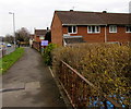
There are currently over 7.5m images from over14,400 individuals and you can help contribute to the project by visiting https://www.geograph.org.uk
Image Map
Images are licensed for reuse under creativecommons.org/licenses/by-sa/2.0
Notes
- Clicking on the map will re-center to the selected point.
- The higher the marker number, the further away the image location is from the centre of the postcode.
Image Listing (232 Images Found)
Images are licensed for reuse under creativecommons.org/licenses/by-sa/2.0
Image
Details
Distance
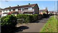
1
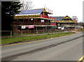
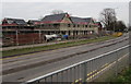
Willis construction site, Henllys Way, Cwmbran
Houses are being built in March 2018.
Image: © Jaggery
Taken: 24 Mar 2018
0.01 miles
2
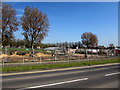
Fenced-off north side of Henllys Way, Cwmbran
Temporary fencing encloses the site of a demolished plant nursery in early April 2017.
Image: © Jaggery
Taken: 9 Apr 2017
0.01 miles
3
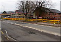
Yellow temporary barriers on the north side of Henllys Way, Cwmbran
At the edge of a Willis construction site in March 2018.
Image: © Jaggery
Taken: 24 Mar 2018
0.02 miles
4
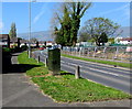
Henllys Way telecoms cabinet, Cwmbran
The BT cabinet is near the corner of Trem Twynbarlwm.
Image: © Jaggery
Taken: 9 Apr 2017
0.03 miles
5
Houses at the northern end of Fetty Place, Cwmbran
Viewed from the pavement on the south side of Henllys Way.
Image: © Jaggery
Taken: 24 Mar 2018
0.03 miles
6
Junction of Trem Twynbarlwm and Henllys Way, Cwmbran
White-on-blue signs indicating a combined footpath and cycleway face the northern end of Trem Twynbarlwm.
Image: © Jaggery
Taken: 9 Apr 2017
0.03 miles
7
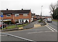
Corner of Henllys Way and Trem Twynbarlwm, Cwmbran
Trem Twynbarlwm is on the left.
Ahead are the ends of several rows of houses located between Henllys Way and Coed Glas.
Image: © Jaggery
Taken: 9 Mar 2013
0.03 miles
8
New houses, Henllys Way, Cwmbran
Willis construction site viewed in March 2018.
Image: © Jaggery
Taken: 24 Mar 2018
0.04 miles
9
Fetty Place houses, Cwmbran
Houses at the northern end of Fetty Place viewed from the Henllys Way pavement.
Image: © Jaggery
Taken: 9 Apr 2017
0.04 miles
10
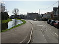
Broadweir Road, Cwmbran
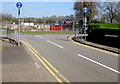
To the left is a footpath and cycleway, part of route 49. This part of the former Monmouthshire & Brecon canal is now only a fragment, separated from fragments to the north and south.
Image: © Jaggery
Taken: 8 Apr 2010
0.04 miles