IMAGES TAKEN NEAR TO
Cwm-y-Nant Fields, CWMBRAN, NP44 3PA
Introduction
This page details the photographs taken nearby to Cwm-y-Nant Fields, NP44 3PA by members of the Geograph project.
The Geograph project started in 2005 with the aim of publishing, organising and preserving representative images for every square kilometre of Great Britain, Ireland and the Isle of Man.

There are currently over 7.5m images from over14,400 individuals and you can help contribute to the project by visiting https://www.geograph.org.uk
Image Map
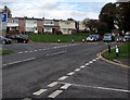
Images are licensed for reuse under creativecommons.org/licenses/by-sa/2.0
Notes
- Clicking on the map will re-center to the selected point.
- The higher the marker number, the further away the image location is from the centre of the postcode.
Image Listing (224 Images Found)
Images are licensed for reuse under creativecommons.org/licenses/by-sa/2.0
Image
Details
Distance
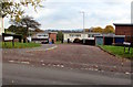
1
Cocker Avenue semis, Cwmbran
Semi-detached houses at the NE end of Cocker Avenue, viewed from the SW end of Wesley Street.
Image: © Jaggery
Taken: 9 Apr 2017
0.04 miles
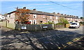
2
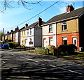
Terraced housing, Wesley Street, Cwmbran
A terraced block of stone-built houses on Wesley Street, between Wesley Close and Orchard Place.
Image: © Jaggery
Taken: 31 Dec 2009
0.05 miles
3
Orchard Place, Cwmbran
From Wesley Street, Orchard Place leads to The Beeches.
Image: © Jaggery
Taken: 9 Apr 2017
0.05 miles
4
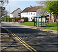
Cocker Avenue bus stop and shelter, Cwmbran
This stop for Cwmbran town centre & bus station.
Image: © Jaggery
Taken: 9 Apr 2017
0.05 miles
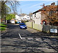
5
Milton Close, St Dials, Cwmbran
Cul-de-sac on the east side of Greenmeadow Way.
Image: © Jaggery
Taken: 20 Oct 2016
0.06 miles
6
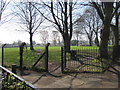
Cwmbran Park entrance gate, Cwmbran
From Wesley Street into the northern corner of the park.
Image: © Jaggery
Taken: 9 Apr 2017
0.07 miles
7
Greenmeadow Way speed bumps, Cwmbran
Part of traffic calming measures on a road in the St Dials area of Cwmbran.
Image: © Jaggery
Taken: 20 Oct 2016
0.08 miles
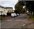
8
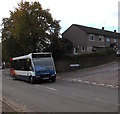
Stagecoach bus in Greenmeadow Way, St Dials, Cwmbran
The bus on Route 5 passes the Wordsworth Close junction.
Image: © Jaggery
Taken: 20 Oct 2016
0.09 miles
9
Traffic calming on Greenmeadow Way, St Dials, Cwmbran
The car on the right is passing through a short narrowing of the road to the width of one lane.
The sign on the left shows that vehicles on this side have priority over oncoming vehicles.
Image: © Jaggery
Taken: 20 Oct 2016
0.09 miles
10
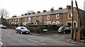
Wesley Street houses, Cwmbran
Row of houses extending for 75 metres from the corner of Orchard Place (on the left) to Wesley Close.
Image: © Jaggery
Taken: 9 Apr 2017
0.10 miles