IMAGES TAKEN NEAR TO
St. Dials Road, CWMBRAN, NP44 3NZ
Introduction
This page details the photographs taken nearby to St. Dials Road, NP44 3NZ by members of the Geograph project.
The Geograph project started in 2005 with the aim of publishing, organising and preserving representative images for every square kilometre of Great Britain, Ireland and the Isle of Man.

There are currently over 7.5m images from over14,400 individuals and you can help contribute to the project by visiting https://www.geograph.org.uk
Image Map
Images are licensed for reuse under creativecommons.org/licenses/by-sa/2.0
Notes
- Clicking on the map will re-center to the selected point.
- The higher the marker number, the further away the image location is from the centre of the postcode.
Image Listing (302 Images Found)
Images are licensed for reuse under creativecommons.org/licenses/by-sa/2.0
Image
Details
Distance
1
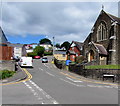
Steep ascent away from Old Cwmbran
Commercial Street ascends towards Hill Top Road and St Dials Road.
St Gabriel's Church https://www.geograph.org.uk/photo/6497494 is on the right.
Image: © Jaggery
Taken: 15 May 2020
0.02 miles
2
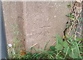
Ordnance Survey Cut Mark
This OS cut mark can be found on the wall west side of St Dials Road. It marks a point 89.922m above mean sea level.
Image: © Adrian Dust
Taken: 10 Sep 2020
0.02 miles
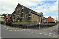
3
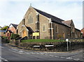
St Gabriels Church In Wales, Old Cwmbran
Located on the corner of Commercial Street and Clomendy Road. St Gabriels is the parish church of Cwmbran. It opened in 1907.
Image: © Jaggery
Taken: 31 Dec 2009
0.04 miles
4
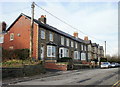
Clomendy Road, Old Cwmbran
Houses on the west side of Clomendy Road.
Image: © Jaggery
Taken: 31 Dec 2009
0.04 miles
5
St Gabriel's Memorial Church Hall, Old Cwmbran
Located on steep Commercial Street, next to St Gabriel's Church. http://www.geograph.org.uk/photo/1641660
Image: © Jaggery
Taken: 30 Jan 2011
0.04 miles
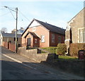
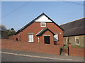
6
St Gabriel's Memorial Church Hall in Old Cwmbran
On the north side of Commercial Street a few metres west of St Gabriel's Church.
Image: © Jaggery
Taken: 16 Feb 2019
0.04 miles
7
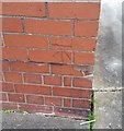
Ordnance Survey Cut Mark
This OS cut mark can be found on St Gabriel's Church Hall. It marks a point 75.267m above mean sea level.
Image: © Adrian Dust
Taken: 10 Sep 2020
0.04 miles
8

East side of St Gabriel's Church, Cwmbran
Clomendy Road side of the Church in Wales church in the Rectorial Benefice of Cwmbran in the Diocese of Monmouth.
Image: © Jaggery
Taken: 16 Feb 2019
0.05 miles
9
St Gabriel's, Old Cwmbran
Church in Wales church in the Diocese of Monmouth set above the corner of Commercial Street and Clomendy Road. The building in the Decorated Style dates from 1907. Viewed in May 2020. In common with other places of worship in the UK, St Gabriel's has been closed since late March 2020 during the nationwide Coronavirus (COVID-19) pandemic lockdown.
Image: © Jaggery
Taken: 15 May 2020
0.05 miles
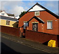
10
St Gabriel's Church Hall
St Gabriel's Memorial Church Hall in Old Cwmbran.
Image: © David Roberts
Taken: 21 Mar 2009
0.05 miles