IMAGES TAKEN NEAR TO
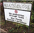
Keats Close, CWMBRAN, NP44 3NX
Introduction
This page details the photographs taken nearby to Keats Close, NP44 3NX by members of the Geograph project.
The Geograph project started in 2005 with the aim of publishing, organising and preserving representative images for every square kilometre of Great Britain, Ireland and the Isle of Man.

There are currently over 7.5m images from over14,400 individuals and you can help contribute to the project by visiting https://www.geograph.org.uk
Image Map
Images are licensed for reuse under creativecommons.org/licenses/by-sa/2.0
Notes
- Clicking on the map will re-center to the selected point.
- The higher the marker number, the further away the image location is from the centre of the postcode.
Image Listing (178 Images Found)
Images are licensed for reuse under creativecommons.org/licenses/by-sa/2.0
Image
Details
Distance
1
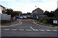
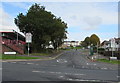
Keats Close, St Dials, Cwmbran
Viewed across Greenmeadow Way.
Image: © Jaggery
Taken: 20 Oct 2016
0.03 miles
2
Keats Close telecoms cabinet, St Dials, Cwmbran
The dark green cabinet is near the Greenmeadow Way junction, on the right here. http://www.geograph.org.uk/photo/5162054
Image: © Jaggery
Taken: 20 Oct 2016
0.04 miles
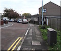
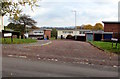
3
Greenmeadow Way speed bumps, Cwmbran
Part of traffic calming measures on a road in the St Dials area of Cwmbran.
Image: © Jaggery
Taken: 20 Oct 2016
0.04 miles
4
Monolingual and bilingual on a St Dials corner, Cwmbran
The English only sign and English/Welsh sign are on the right here. http://www.geograph.org.uk/photo/5162054
Image: © Jaggery
Taken: 20 Oct 2016
0.05 miles
5
Southern end of Greenmeadow Way, St Dials, Cwmbran
Looking NNE up Greenmeadow Way from Henllys Way. Henllys Way Post Office http://www.geograph.org.uk/photo/5161994 is on the left.
Image: © Jaggery
Taken: 20 Oct 2016
0.05 miles
6
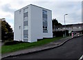
Small block of flats, Greenmeadow Way, St Dials, Cwmbran
Opposite the Keats Close junction.
Image: © Jaggery
Taken: 20 Oct 2016
0.06 miles
7
Milton Close, St Dials, Cwmbran
Cul-de-sac on the east side of Greenmeadow Way.
Image: © Jaggery
Taken: 20 Oct 2016
0.06 miles
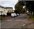
8
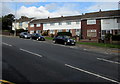
Cars and houses, St Dials, Cwmbran
Viewed across Henllys Way. The houses on the left are near the corner of Greenmeadow Way.
Image: © Jaggery
Taken: 20 Oct 2016
0.06 miles
9
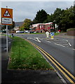
Bilingual warning sign - Patrol/Hebryngwr, St Dials, Cwmbran
The English/Welsh sign is alongside Henllys Way on the approach to a school.
Henllys Way Post Office http://www.geograph.org.uk/photo/5161994 is ahead on the right.
Image: © Jaggery
Taken: 20 Oct 2016
0.07 miles
10
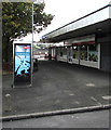
BT phonebox near Henllys Way Post Office, St Dials, Cwmbran
The post office http://www.geograph.org.uk/photo/5161994 is behind the Spar store.
Image: © Jaggery
Taken: 20 Oct 2016
0.07 miles