IMAGES TAKEN NEAR TO
Hill Top, CWMBRAN, NP44 3NS
Introduction
This page details the photographs taken nearby to Hill Top, NP44 3NS by members of the Geograph project.
The Geograph project started in 2005 with the aim of publishing, organising and preserving representative images for every square kilometre of Great Britain, Ireland and the Isle of Man.

There are currently over 7.5m images from over14,400 individuals and you can help contribute to the project by visiting https://www.geograph.org.uk
Image Map
Images are licensed for reuse under creativecommons.org/licenses/by-sa/2.0
Notes
- Clicking on the map will re-center to the selected point.
- The higher the marker number, the further away the image location is from the centre of the postcode.
Image Listing (294 Images Found)
Images are licensed for reuse under creativecommons.org/licenses/by-sa/2.0
Image
Details
Distance
1
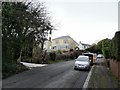
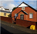
Commercial Street climbs towards St Dials Road, Cwmbran
Commercial Street heads away from Old Cwmbran as it climbs towards St Dials Road.
The houses are on the corner of Hill Top.
Image: © Jaggery
Taken: 31 Dec 2009
0.01 miles
2
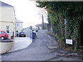
Hill Top, Cwmbran
Hill Top heads away from the junction of Commercial Street and St Dials Road.
Image: © Jaggery
Taken: 31 Dec 2009
0.01 miles
3
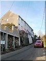
Southern end of St Dials Road, Cwmbran
Viewed from the junction with Hill Top, near the point where the southern end of St Dials Road becomes the northern end of Commercial Street, Old Cwmbran.
The sign on the right shows RESIDENTS ACCESS ONLY. Access further along the road is blocked by concrete posts. http://www.geograph.org.uk/photo/2291026
Image: © Jaggery
Taken: 30 Jan 2011
0.01 miles
4
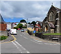
Steep ascent away from Old Cwmbran
Commercial Street ascends towards Hill Top Road and St Dials Road.
St Gabriel's Church https://www.geograph.org.uk/photo/6497494 is on the right.
Image: © Jaggery
Taken: 15 May 2020
0.03 miles
5
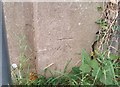
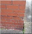
Ordnance Survey Cut Mark
This OS cut mark can be found on the wall west side of St Dials Road. It marks a point 89.922m above mean sea level.
Image: © Adrian Dust
Taken: 10 Sep 2020
0.03 miles
6
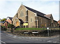
St Gabriels Church In Wales, Old Cwmbran
Located on the corner of Commercial Street and Clomendy Road. St Gabriels is the parish church of Cwmbran. It opened in 1907.
Image: © Jaggery
Taken: 31 Dec 2009
0.06 miles
7
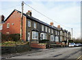
Clomendy Road, Old Cwmbran
Houses on the west side of Clomendy Road.
Image: © Jaggery
Taken: 31 Dec 2009
0.06 miles
8
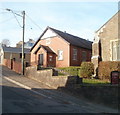
St Gabriel's Memorial Church Hall, Old Cwmbran
Located on steep Commercial Street, next to St Gabriel's Church. http://www.geograph.org.uk/photo/1641660
Image: © Jaggery
Taken: 30 Jan 2011
0.06 miles
9
St Gabriel's Memorial Church Hall in Old Cwmbran
On the north side of Commercial Street a few metres west of St Gabriel's Church.
Image: © Jaggery
Taken: 16 Feb 2019
0.06 miles
10
Ordnance Survey Cut Mark
This OS cut mark can be found on St Gabriel's Church Hall. It marks a point 75.267m above mean sea level.
Image: © Adrian Dust
Taken: 10 Sep 2020
0.06 miles