IMAGES TAKEN NEAR TO
Taliesin, Forgeside, CWMBRAN, NP44 3NR
Introduction
This page details the photographs taken nearby to Taliesin, Forgeside, NP44 3NR by members of the Geograph project.
The Geograph project started in 2005 with the aim of publishing, organising and preserving representative images for every square kilometre of Great Britain, Ireland and the Isle of Man.

There are currently over 7.5m images from over14,400 individuals and you can help contribute to the project by visiting https://www.geograph.org.uk
Image Map
Images are licensed for reuse under creativecommons.org/licenses/by-sa/2.0
Notes
- Clicking on the map will re-center to the selected point.
- The higher the marker number, the further away the image location is from the centre of the postcode.
Image Listing (604 Images Found)
Images are licensed for reuse under creativecommons.org/licenses/by-sa/2.0
Image
Details
Distance
1
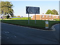
One way, two languages, three words, Maendy Way, Cwmbran
The English/Welsh One way/Unffordd sign is near the point where Maendy Way splits into two one-way carriageways.
Image: © Jaggery
Taken: 5 Oct 2016
0.02 miles
2
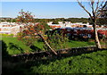
Nearly horizontal tree below Maendy Way, Cwmbran
Whatever caused the tree to be aligned this way (perhaps a vehicle collision, or subsidence or vandalism)
doesn't appear to have seriously damaged the tree which has many red berries on October 5th 2016.
Image: © Jaggery
Taken: 5 Oct 2016
0.04 miles
3
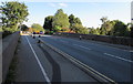
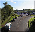
Cwmbran Drive approaches Maendy Way bridge, Cwmbran
Heading south towards the centre of Cwmbran, the A4051 (Cwmbran Drive) passes under the bridge carrying Maendy Way. Much of Cwmbran Drive uses the route of a dismantled railway line than ran from Newport via Llantarnam.
Image: © Jaggery
Taken: 13 Oct 2011
0.05 miles
4
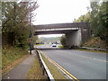
Maendy Road bridge, Cwmbran
The bridge carries Maendy Road over the A4051 Cwmbran Drive.
Image: © Jaggery
Taken: 5 Oct 2016
0.05 miles
5
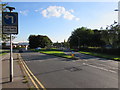
Directions signs facing Maendy Way, Cwmbran
Left for Newport, Pontypool and the Springvale, Pontnewydd, Greenmeadow and Upper Cwmbran areas of Cwmbran. Right for Cwmbran town centre, railway station and free car parks.
Image: © Jaggery
Taken: 5 Oct 2016
0.05 miles
6
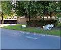
Abandoned supermarket trolleys, Maendy Way, Cwmbran
The Asda shopping trolleys have been left about 100 metres from the town centre Asda superstore. http://www.geograph.org.uk/photo/5325471
Image: © Jaggery
Taken: 5 Oct 2016
0.05 miles
7
Forgeside, Cwmbran
Viewed from Woodside Road past the Forgeside businesses nameboard
looking towards a telephone exchange.
Image: © Jaggery
Taken: 9 Apr 2014
0.06 miles
8
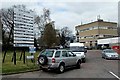
Cwmbran Drive towards Aldi, Cwmbran
Viewed from the Maendy Way overbridge. The Cwmbran Aldi supermarket is in the background.
Image: © Jaggery
Taken: 5 Oct 2016
0.06 miles
9
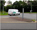
Pilkington Automotive Glass van enters Cwmbran Drive, Cwmbran
The white van enters the A4051 Cwmbran Drive towards Pontypool.
Image: © Jaggery
Taken: 23 Jul 2016
0.06 miles
10
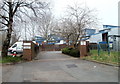
Entrance to Taliesin, Cwmbran
Taliesin is a group of 58 flats located at the northern end of a road named Forgeside.
Image: © Jaggery
Taken: 26 Mar 2011
0.06 miles