IMAGES TAKEN NEAR TO
Greenmeadow Way, CWMBRAN, NP44 3NQ
Introduction
This page details the photographs taken nearby to Greenmeadow Way, NP44 3NQ by members of the Geograph project.
The Geograph project started in 2005 with the aim of publishing, organising and preserving representative images for every square kilometre of Great Britain, Ireland and the Isle of Man.

There are currently over 7.5m images from over14,400 individuals and you can help contribute to the project by visiting https://www.geograph.org.uk
Image Map
Images are licensed for reuse under creativecommons.org/licenses/by-sa/2.0
Notes
- Clicking on the map will re-center to the selected point.
- The higher the marker number, the further away the image location is from the centre of the postcode.
Image Listing (147 Images Found)
Images are licensed for reuse under creativecommons.org/licenses/by-sa/2.0
Image
Details
Distance
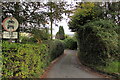
1
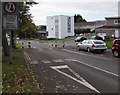
Bilingual Give Way/Ildiwch sign, Greenmeadow Way, St Dials, Cwmbran
The bilingual (English/Welsh) sign shows that oncoming vehicles
have priority through the narrowing of the road to one lane.
Image: © Jaggery
Taken: 20 Oct 2016
0.02 miles
2
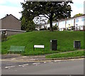
Bench and telecoms cabinets on a St Dials corner, Cwmbran
On the corner of Greenmeadow Way and Shakespeare Road in the St Dials area of Cwmbran.
Image: © Jaggery
Taken: 20 Oct 2016
0.03 miles
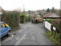
3
Pen-y-Waun Close, Cwmbran
Viewed from near the junction with Hill Top.
Image: © Jaggery
Taken: 31 Dec 2009
0.03 miles
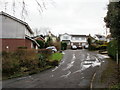
4
Traffic calming on Greenmeadow Way, St Dials, Cwmbran
The car on the right is passing through a short narrowing of the road to the width of one lane.
The sign on the left shows that vehicles on this side have priority over oncoming vehicles.
Image: © Jaggery
Taken: 20 Oct 2016
0.03 miles
5
Pen-y-waun Road, Cwmbran
Pen-y-waun Road descends from Greenmeadow Way. No motor vehicles except for access.
Image: © Jaggery
Taken: 20 Oct 2016
0.04 miles
6
Ordnance Survey Cut Mark
This OS cut mark can be found on Ardath, Penywauh Road. It marks a point 87.084m above mean sea level.
Image: © Adrian Dust
Taken: 10 Sep 2020
0.04 miles
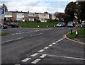
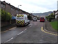
7
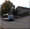
Stagecoach bus in Greenmeadow Way, St Dials, Cwmbran
The bus on Route 5 passes the Wordsworth Close junction.
Image: © Jaggery
Taken: 20 Oct 2016
0.04 miles
8
Milton Close, St Dials, Cwmbran
Cul-de-sac on the east side of Greenmeadow Way.
Image: © Jaggery
Taken: 20 Oct 2016
0.05 miles
9
Hill Top, Cwmbran
Looking southwestwards along Hill Top from the Yew Tree Terrace turning.
Image: © Jaggery
Taken: 31 Dec 2009
0.05 miles
10
Eastern end of Shakespeare Road, St Dials, Cwmbran
Viewed across Greenmeadow Way. Shakespeare Road extends westwards to Blenheim Road, about 420 metres ahead.
Image: © Jaggery
Taken: 20 Oct 2016
0.05 miles