IMAGES TAKEN NEAR TO
Oak Street, CWMBRAN, NP44 3NE
Introduction
This page details the photographs taken nearby to Oak Street, NP44 3NE by members of the Geograph project.
The Geograph project started in 2005 with the aim of publishing, organising and preserving representative images for every square kilometre of Great Britain, Ireland and the Isle of Man.

There are currently over 7.5m images from over14,400 individuals and you can help contribute to the project by visiting https://www.geograph.org.uk
Image Map
Images are licensed for reuse under creativecommons.org/licenses/by-sa/2.0
Notes
- Clicking on the map will re-center to the selected point.
- The higher the marker number, the further away the image location is from the centre of the postcode.
Image Listing (345 Images Found)
Images are licensed for reuse under creativecommons.org/licenses/by-sa/2.0
Image
Details
Distance
1
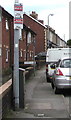
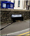
Cold Calling Control Zone notice, Oak Street, Cwmbran
On the lamppost here https://www.geograph.org.uk/photo/6497215 alongside School Court. Cold calling is the contacting by businesses or their agents of people thought to be potential customers, without the contact having been prearranged.
Image: © Jaggery
Taken: 15 May 2020
0.01 miles
2
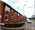
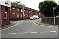
School Court, Cwmbran
Brick housing in Oak Street near the corner of Commercial Street in Old Cwmbran.
Image: © Jaggery
Taken: 15 May 2020
0.01 miles
3
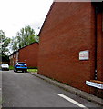
No Public Thoroughfare notice, School Court, Cwmbran
Viewed from the corner of Oak Street.
Image: © Jaggery
Taken: 15 May 2020
0.01 miles
4
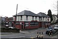
The Halfway, Old Cwmbran
Located on Commercial Street, Old Cwmbran.
I have not yet discovered which two points it is half way between.
Image: © Jaggery
Taken: 31 Dec 2009
0.01 miles
5
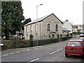
Elim United Reformed Church , Old Cwmbran
Located on Commercial Street, Old Cwmbran. Built in 1844, the church was Grade II listed in 1998.
Image: © Jaggery
Taken: 31 Dec 2009
0.01 miles
6
One-way signs at the NE end of Oak Street, Cwmbran
Facing Commercial Street in Old Cwmbran.
Image: © Jaggery
Taken: 15 May 2020
0.01 miles
7
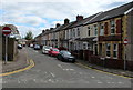
NE along Oak Street, Old Cwmbran
From Broadweir Road looking past No Entry signs.
Image: © Jaggery
Taken: 15 May 2020
0.02 miles
8
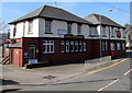
The Halfway, Old Cwmbran
Viewed across Commercial Street in April 2017.
The Halfway Hotel sign on the wall was not here at the end of 2009. http://www.geograph.org.uk/photo/1640958
A notice on the left shows that a mobile butcher is here every Friday from 8am - 2pm.
Image: © Jaggery
Taken: 9 Apr 2017
0.02 miles
9
Oak Street bilingual name sign, Old Cwmbran
The sign on the corner of Commercial Street shows that Oak Street is Stryd y Dderwen in Welsh. Cwmbran United Reformed Church is in the background.
Image: © Jaggery
Taken: 15 May 2020
0.02 miles
10

Simonds Hop Leaf trademark sign in Old Cwmbran
Faded and rusty in February 2019, the sign is on the right here https://www.geograph.org.uk/photo/5345378 on the wall of the Halfway.
Simonds brewery was founded in Broad Street Reading by W.B.Simonds in 1785.
The company amalgamated with Courage & Barclay in 1960.
Image: © Jaggery
Taken: 16 Feb 2019
0.02 miles