IMAGES TAKEN NEAR TO
The Beeches, CWMBRAN, NP44 3LL
Introduction
This page details the photographs taken nearby to The Beeches, NP44 3LL by members of the Geograph project.
The Geograph project started in 2005 with the aim of publishing, organising and preserving representative images for every square kilometre of Great Britain, Ireland and the Isle of Man.

There are currently over 7.5m images from over14,400 individuals and you can help contribute to the project by visiting https://www.geograph.org.uk
Image Map
Images are licensed for reuse under creativecommons.org/licenses/by-sa/2.0
Notes
- Clicking on the map will re-center to the selected point.
- The higher the marker number, the further away the image location is from the centre of the postcode.
Image Listing (232 Images Found)
Images are licensed for reuse under creativecommons.org/licenses/by-sa/2.0
Image
Details
Distance
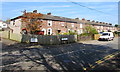
1
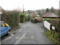
Hill Top, Cwmbran
Looking southwestwards along Hill Top from the Yew Tree Terrace turning.
Image: © Jaggery
Taken: 31 Dec 2009
0.05 miles
2
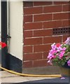
Ordnance Survey Cut Mark
This OS cut mark can be found on Ardath, Penywauh Road. It marks a point 87.084m above mean sea level.
Image: © Adrian Dust
Taken: 10 Sep 2020
0.06 miles
3
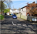
Orchard Place, Cwmbran
From Wesley Street, Orchard Place leads to The Beeches.
Image: © Jaggery
Taken: 9 Apr 2017
0.07 miles
4
Milton Close, St Dials, Cwmbran
Cul-de-sac on the east side of Greenmeadow Way.
Image: © Jaggery
Taken: 20 Oct 2016
0.08 miles
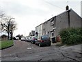
5
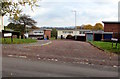
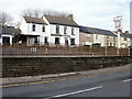
Wesley Street houses, Cwmbran
Row of houses extending for 75 metres from the corner of Orchard Place (on the left) to Wesley Close.
Image: © Jaggery
Taken: 9 Apr 2017
0.08 miles
6
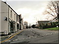
Wesley Street, Old Cwmbran
Looking along Wesley Street from Commercial Street.
Image: © Jaggery
Taken: 31 Dec 2009
0.09 miles
7
Prospect Place (N), Old Cwmbran
The northern half of Prospect Place, viewed here from Commercial Street, is separated from the southern half by a 30-metre wide island of trees. http://www.geograph.org.uk/photo/1641001 to the southern half.
Image: © Jaggery
Taken: 31 Dec 2009
0.09 miles
8
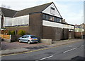
Wesley Community Centre, Cwmbran
Located in Wesley Street. The building, now much modified, was previously Wesleyan Methodist Church. The year 1878 is inscribed on the wall on the far side of the building.
Image: © Jaggery
Taken: 31 Dec 2009
0.09 miles
9
The Mount Pleasant, Wesley Street, Old Cwmbran
Image: © Jaggery
Taken: 31 Dec 2009
0.09 miles
10
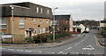
Broadweir Road, Cwmbran
Viewed from Wesley Street.
Image: © Jaggery
Taken: 31 Dec 2009
0.09 miles