IMAGES TAKEN NEAR TO
Maendy Way, CWMBRAN, NP44 3LH
Introduction
This page details the photographs taken nearby to Maendy Way, NP44 3LH by members of the Geograph project.
The Geograph project started in 2005 with the aim of publishing, organising and preserving representative images for every square kilometre of Great Britain, Ireland and the Isle of Man.

There are currently over 7.5m images from over14,400 individuals and you can help contribute to the project by visiting https://www.geograph.org.uk
Image Map
Images are licensed for reuse under creativecommons.org/licenses/by-sa/2.0
Notes
- Clicking on the map will re-center to the selected point.
- The higher the marker number, the further away the image location is from the centre of the postcode.
Image Listing (206 Images Found)
Images are licensed for reuse under creativecommons.org/licenses/by-sa/2.0
Image
Details
Distance
1
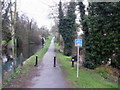
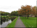
National Cycle Network Route 49, Cwmbran
Route 49 heads north from Maendy Way, Cwmbran along the towpath of the former Monmouthshire and Brecon canal. The canal is fragmented in this part of Cwmbran. For example, it does not cross Maendy Way, and there is a gap of about 200 metres a little north of here.
Image: © Jaggery
Taken: 3 Apr 2010
0.03 miles
2
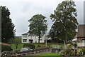
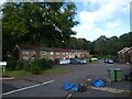
Woodside House, Forge Hammer
White house now a funeral home.
Image: © M J Roscoe
Taken: 11 Sep 2021
0.03 miles
3
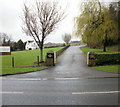
Entrance drive to Peterson Funeral Home, Woodside House, Cwmbran
Viewed from Maendy Way. http://www.geograph.org.uk/photo/1784041 to Woodside House.
Image: © Jaggery
Taken: 3 Apr 2010
0.04 miles
4
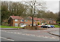
Ty Box Road, Cwmbran
Houses on the west side of the road, viewed from Maendy Way.
Image: © Jaggery
Taken: 3 Apr 2010
0.04 miles
6
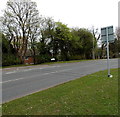
Traffic counting strips across Maendy Way, Cwmbran
The strips contain sensors that send traffic data (as vehicles pass over them)
to a MetroCount box padlocked to the metal post on the right.
Image: © Jaggery
Taken: 9 Apr 2014
0.05 miles
7
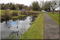
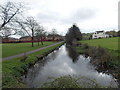
Former Monmouthshire and Brecon Canal, Cwmbran
The former Monmouthshire and Brecon Canal near Cwmbran. As ever, canals do appear to be a magnet for shopping trolley.
Image: © Philip Halling
Taken: 12 Apr 2013
0.05 miles
8
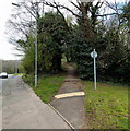
Footpath from Maendy Way to Church Wood Road, Cwmbran
The path heads towards the SE corner of Church Wood Road, about 100 metres ahead.
Image: © Jaggery
Taken: 9 Apr 2014
0.06 miles
9
Monmouthshire & Brecon: approaching Maendy Way
Image: © Gareth James
Taken: 23 Oct 2011
0.06 miles
10
South from Maendy Way along a disused fragment of canal in Cwmbran
In Cwmbran, the remains of the disused Monmouthshire & Brecon Canal are fragmentary, with houses and roads built across many former parts of the canal.
Image: © Jaggery
Taken: 9 Apr 2014
0.06 miles