IMAGES TAKEN NEAR TO
Llantarnam Close, CWMBRAN, NP44 3JX
Introduction
This page details the photographs taken nearby to Llantarnam Close, NP44 3JX by members of the Geograph project.
The Geograph project started in 2005 with the aim of publishing, organising and preserving representative images for every square kilometre of Great Britain, Ireland and the Isle of Man.

There are currently over 7.5m images from over14,400 individuals and you can help contribute to the project by visiting https://www.geograph.org.uk
Image Map
Images are licensed for reuse under creativecommons.org/licenses/by-sa/2.0
Notes
- Clicking on the map will re-center to the selected point.
- The higher the marker number, the further away the image location is from the centre of the postcode.
Image Listing (276 Images Found)
Images are licensed for reuse under creativecommons.org/licenses/by-sa/2.0
Image
Details
Distance
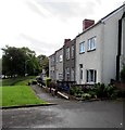
1
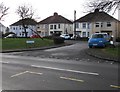
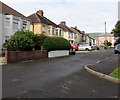
Llantarnam Close semis, Cwmbran
Semi-detached houses viewed from a Victoria Street bus stop.
The name sign shows that Llantarnam Close is Clos Llantarnam in Welsh.
Image: © Jaggery
Taken: 22 Jan 2018
0.01 miles
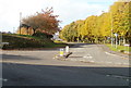
2
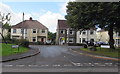
Junction of Llantarnam Close and Victoria Street, Old Cwmbran
A short connecting road from Victoria Street leads to houses in Llantarnam Close.
Image: © Jaggery
Taken: 23 Sep 2016
0.01 miles
3
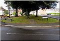
Boulders and trees on a grassy strip, Llantarnam Close, Old Cwmbran
If the boulders are intended to prevent vehicles parking on the grass,
the gap between these two boulders looks a little too wide...
Image: © Jaggery
Taken: 23 Sep 2016
0.02 miles
4
Welsh side of a bus stop sign in Old Cwmbran
The text on this side of the Victoria Street bus stop sign is in Welsh (Safle Bws, Heol y Plas).
The opposite side shows Bus Stop and Grange Road.
The cars on the right are on the corner of Victoria Street and Grange Road.
Image: © Jaggery
Taken: 23 Sep 2016
0.03 miles
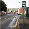
5
This way to Old Cwmbran
Signs on both sides of Victoria Street point the way to Old Cwmbran.
Image: © Jaggery
Taken: 27 Oct 2010
0.03 miles
6
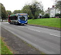
X3 bus in Old Cwmbran
A Stagecoach bus on route X3 from Cardiff to Pontypool ascends Victoria Street in Old Cwmbran.
Image: © Jaggery
Taken: 23 Sep 2016
0.03 miles
7
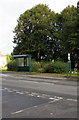
Victoria Street bus stop and shelter, Old Cwmbran
Located opposite Llantarnam Close. This side of the road for buses to Newport.
Image: © Jaggery
Taken: 23 Sep 2016
0.03 miles
8
Short row of houses, Old Cwmbran
Between Llantarnam Close (on this side) and Henllys Way.
Image: © Jaggery
Taken: 23 Sep 2016
0.04 miles
9
Llantarnam Close houses, Old Cwmbran
Semi-detached houses set back from the south side of Victoria Street out of shot on the right.
Image: © Jaggery
Taken: 23 Sep 2016
0.04 miles
10
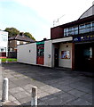
Dave Toms Turf Accountant, Cwmbran
Betting shop in Oldbury Road, next door to Cwmbran Working Men's Band Club and Institute http://www.geograph.org.uk/photo/2133979
Image: © Jaggery
Taken: 17 Sep 2014
0.04 miles