IMAGES TAKEN NEAR TO
Lakeside, CWMBRAN, NP44 3HD
Introduction
This page details the photographs taken nearby to Lakeside, NP44 3HD by members of the Geograph project.
The Geograph project started in 2005 with the aim of publishing, organising and preserving representative images for every square kilometre of Great Britain, Ireland and the Isle of Man.

There are currently over 7.5m images from over14,400 individuals and you can help contribute to the project by visiting https://www.geograph.org.uk
Image Map
Images are licensed for reuse under creativecommons.org/licenses/by-sa/2.0
Notes
- Clicking on the map will re-center to the selected point.
- The higher the marker number, the further away the image location is from the centre of the postcode.
Image Listing (81 Images Found)
Images are licensed for reuse under creativecommons.org/licenses/by-sa/2.0
Image
Details
Distance
1
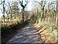
Central section of Ty Coch Lane, Llantarnam
Now a quiet country lane with very little traffic hereabouts, Ty Coch Lane was formerly a through route for motor vehicles between Pentre Lane in the south and Llantarnam Park Way in the north.
The road is now blocked http://www.geograph.org.uk/photo/3244936 for motor vehicles near the Pentre Lane end.
Image: © Jaggery
Taken: 1 Dec 2012
0.07 miles
2
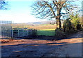
Two gates, Ty Coch Lane, Llantarnam
The gate on the left leads to a track. The other one is a field gate.
On the left is the perimeter fence of an electricity substation.
Image: © Jaggery
Taken: 1 Dec 2012
0.07 miles
3
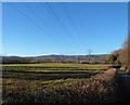
Rural power lines, Llantarnam
A view from Ty Coch Lane looking towards a distant electricity substation.
Image: © Jaggery
Taken: 1 Dec 2012
0.11 miles
4
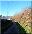
Electricity lines over Ty Coch Lane, Llantarnam
Looking towards a pylon at the edge of Cottage Farm.
Image: © Jaggery
Taken: 1 Dec 2012
0.12 miles
5

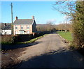
Southwest along Lakeside, Llantarnam, Cwmbran
Dead end road connecting with Llantarnam Park Way behind the camera.
Some maps show this road as Lakeside Close. In April 2020, nearby signs show Lakeside.
Turn left here for Safran. https://www.geograph.org.uk/photo/6451145
Image: © Jaggery
Taken: 23 Apr 2020
0.13 miles
6

Lakeside southern junction
This is the southern junction of Lakeside and Llantarnam Park Way. http://www.geograph.org.uk/photo/1595279 to the northern junction.
Image: © Jaggery
Taken: 25 Aug 2009
0.13 miles
7
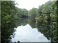
Pond, Llantarnam Park Way, Cwmbran
There are three ponds located between Llantarnam Park Way and Dowlais Brook. This one, about 125 metres long, is between Lake View and Lakeside Close.
Image: © Jaggery
Taken: 21 Sep 2011
0.13 miles
8
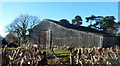
Corrugated building, Cottage Farm, Llantarnam
Viewed from Ty Coch Lane.
Image: © Jaggery
Taken: 1 Dec 2012
0.16 miles
9
Northern edge of the trees alongside Ty Coch Lane, Llantarnam
The course of Ty Coch Lane behind the camera has been mostly tree-lined. http://www.geograph.org.uk/photo/3247780
Image: © Jaggery
Taken: 1 Dec 2012
0.16 miles
10

Safran head office, Llantarnam, Cwmbran
The northwest corner of Safran Seats GB premises in Cwmbran. The site includes Safran's head office, engineering, design office, test centre, production and assembly facilities. Safran also has sites in Camberley (manufacture with specialisation in composite materials and aftersales) and Brackley (design office, engineering and test centre).
Image: © Jaggery
Taken: 23 Apr 2020
0.17 miles