IMAGES TAKEN NEAR TO
Grayson Way, CWMBRAN, NP44 3GD
Introduction
This page details the photographs taken nearby to Grayson Way, NP44 3GD by members of the Geograph project.
The Geograph project started in 2005 with the aim of publishing, organising and preserving representative images for every square kilometre of Great Britain, Ireland and the Isle of Man.

There are currently over 7.5m images from over14,400 individuals and you can help contribute to the project by visiting https://www.geograph.org.uk
Image Map
Images are licensed for reuse under creativecommons.org/licenses/by-sa/2.0
Notes
- Clicking on the map will re-center to the selected point.
- The higher the marker number, the further away the image location is from the centre of the postcode.
Image Listing (198 Images Found)
Images are licensed for reuse under creativecommons.org/licenses/by-sa/2.0
Image
Details
Distance
1
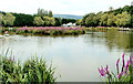
Eyot in Cwmbran Boating Lake
The eyot (small island) is in the middle of the boating lake which is located in the south of Cwmbran, between the Afon Lwyd (river) and the Welsh Marches railway lines.
Image: © Jaggery
Taken: 3 Aug 2011
0.02 miles
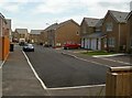
2
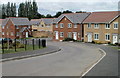
Poplar Place, Llantarnam, Cwmbran
Recently-built houses viewed past the corner of Poppy Field Avenue in September 2016.
Image: © Jaggery
Taken: 22 Sep 2016
0.04 miles
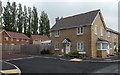
3
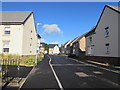
Houses on Grayson Way, Llantarnam
Grayson Way curves away from Llantarnam Road. The houses are recently built, part of the Barratt Homes St Joseph's Meadow development.
Image: © Jaggery
Taken: 7 Aug 2010
0.05 miles
4
Junction of Grayson Way and Llantarnam Road, Cwmbran
From Llantarnam Road, Grayson Way descends towards Poplar Place.
Image: © Jaggery
Taken: 31 Mar 2017
0.05 miles
5
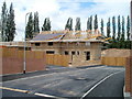
House construction, St Joseph's Meadow, Llantarnam
House construction is in progress at the far end of St Joseph's Meadow, a Barratt development on the north side of Llantarnam Road. Recently completed houses nearby are already occupied.
Image: © Jaggery
Taken: 7 Aug 2010
0.06 miles
6
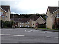
Poplar Place, St Joseph's Meadow, Cwmbran
Poplar Place is at the NW edge of recently-built Barratt Homes houses.
The opposite side of St Joseph's Meadow is accessed from Llantarnam Road via Grayson Way. http://www.geograph.org.uk/photo/1987887
Image: © Jaggery
Taken: 3 Aug 2011
0.06 miles
7
Poplar Place, Llantarnam, Cwmbran
Accessed from Llantarnam Road via Grayson Way, Poplar Place is at the NW edge of recently-built Barratt Homes houses. The name was no doubt chosen because of the similarity to Popular Place...
Image: © Jaggery
Taken: 30 Apr 2014
0.06 miles
8

St Joseph's Meadow, Llantarnam, Cwmbran
Alongside Grayson Way, the name sign on the right shows
St Joseph's Meadow, a recently-built Barratt Homes development.
Image: © Jaggery
Taken: 30 Apr 2014
0.06 miles
9

Openreach van, Llantarnam Road, Cwmbran
The Openreach engineer has just returned to the van after working on the nearby telecoms cabinet.
Openreach is the infrastructure division of the telecommunications company BT Group.
Image: © Jaggery
Taken: 31 Mar 2017
0.07 miles
10
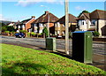
Two telecoms cabinets, Llantarnam Road, Cwmbran
Located near the corner of Brangwyn Avenue.
Image: © Jaggery
Taken: 22 Sep 2016
0.07 miles