IMAGES TAKEN NEAR TO
Henllys Way, CWMBRAN, NP44 3FS
Introduction
This page details the photographs taken nearby to Henllys Way, NP44 3FS by members of the Geograph project.
The Geograph project started in 2005 with the aim of publishing, organising and preserving representative images for every square kilometre of Great Britain, Ireland and the Isle of Man.

There are currently over 7.5m images from over14,400 individuals and you can help contribute to the project by visiting https://www.geograph.org.uk
Image Map
Images are licensed for reuse under creativecommons.org/licenses/by-sa/2.0
Notes
- Clicking on the map will re-center to the selected point.
- The higher the marker number, the further away the image location is from the centre of the postcode.
Image Listing (214 Images Found)
Images are licensed for reuse under creativecommons.org/licenses/by-sa/2.0
Image
Details
Distance
1
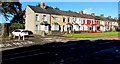
Long row of houses, Llantarnam Road, Cwmbran
The car is parked near the entrance to the Old Cemetery.
Image: © Jaggery
Taken: 22 Sep 2016
0.04 miles
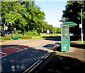
2
Cemetery Gates bus stop and shelter, Llantarnam Road, Cwmbran
This stop is for buses to Cwmbran town centre via Old Cwmbran.
The eastern entrance https://www.geograph.org.uk/photo/2118623 to Cwmbran's old cemetery is out of shot on the left.
Image: © Jaggery
Taken: 29 Jun 2018
0.05 miles
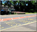
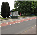
3
Bus stop and shelter near Cwmbran Old Cemetery, Llantarnam
This stop alongside Llantarnam Road is for buses to Cwmbran bus station and destinations beyond.
Image: © Jaggery
Taken: 15 May 2020
0.05 miles
4
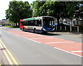
X3 bus for Pontypool in Llantarnam, Cwmbran
Stagecoach bus 28738 is on route X3 from Cardiff to Pontypool in May 2020.
Image: © Jaggery
Taken: 15 May 2020
0.05 miles
5
Green bus shelters, Llantarnam Road, Cwmbran
The bus stop on the right is for buses to Newport.
The bus stop on the left is for buses to Cwmbran bus station via Old Cwmbran.
Image: © Jaggery
Taken: 22 Sep 2016
0.05 miles
6
Llantarnam Road bus stop and shelter, Cwmbran
In May 2020 this is a stop on two Stagecoach bus routes.
Buses on route 23 are for Market Square bus station in
Newport city centre via the Malpas and Crindau areas of Newport.
Buses on route X3 are for Cardiff via Malpas and the M4 motorway.
Image: © Jaggery
Taken: 15 May 2020
0.06 miles
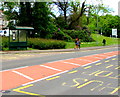
7
Keep Left signs, Llantarnam Road, Cwmbran
Creating a pedestrian refuge in the middle of the road. Ahead for Newport.
Behind the camera for Old Cwmbran and Cwmbran town centre.
Image: © Jaggery
Taken: 15 May 2020
0.06 miles
8

X3 bus, Llantarnam Road, Cwmbran
Stagecoach bus 28738 is travelling towards Old Cwmbran and
Cwmbran bus station on route X3 from Cardiff to Pontypool in May 2020.
Image: © Jaggery
Taken: 15 May 2020
0.06 miles
9
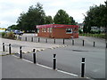
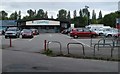
Ellie's Pit Stop Cafe, Cwmbran
Located on the Llantarnam Road edge of a shopping area adjacent to Court Road roundabout.
Fast food, such as sandwiches, snacks, burgers, to eat in or take away.
Image: © Jaggery
Taken: 7 Aug 2010
0.06 miles
10
Somerfield, Llantarnam Road, Cwmbran
Located in a small area of shops and other business premises set back from the east side of Llantarnam Road, adjacent to the Court Road roundabout.
Somerfield was taken over by The Co-operative Group in March 2009. The Somerfield name on the stores is being replaced by the Co-operative Food name in a rolling programme of store conversions, planned for completion by the end of 2010. This view was taken in August 2010.
Update October 2010 The store is now a Co-operative Food supermarket. http://www.geograph.org.uk/photo/2133792
Image: © Jaggery
Taken: 7 Aug 2010
0.06 miles