IMAGES TAKEN NEAR TO
Oakfield Mews, CWMBRAN, NP44 3FJ
Introduction
This page details the photographs taken nearby to Oakfield Mews, NP44 3FJ by members of the Geograph project.
The Geograph project started in 2005 with the aim of publishing, organising and preserving representative images for every square kilometre of Great Britain, Ireland and the Isle of Man.

There are currently over 7.5m images from over14,400 individuals and you can help contribute to the project by visiting https://www.geograph.org.uk
Image Map
Images are licensed for reuse under creativecommons.org/licenses/by-sa/2.0
Notes
- Clicking on the map will re-center to the selected point.
- The higher the marker number, the further away the image location is from the centre of the postcode.
Image Listing (135 Images Found)
Images are licensed for reuse under creativecommons.org/licenses/by-sa/2.0
Image
Details
Distance
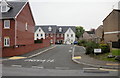
1
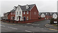
Oakfield Mews, Cwmbran
Houses built in 2007 on the south side of Oakfield Road.
The name sign on the right shows OAKFIELD MEWS PRIVATE ROAD.
The message is emphasised by large white letters on the road surface showing PRIVATE.
Image: © Jaggery
Taken: 9 Mar 2013
0.01 miles
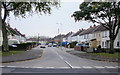
3
Short row of houses, Oakfield Road, Cwmbran
A row of 5 houses on Oakfield Road. The side road on the left is not separately named - it is part of Oakfield Road, and its houses are numbered in the correct sequence.
Image: © Jaggery
Taken: 27 Oct 2010
0.01 miles
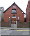
4
Gospel Hall, Oakfield Road, Cwmbran
Many places of worship show their year of construction by an inscription on the building.
The inscription on the tablet above the upper window on this building shows only GOSPEL HALL.
Image: © Jaggery
Taken: 9 Mar 2013
0.02 miles
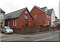
5
Oakfield Mews, Cwmbran
Houses built in 2007, viewed from Oakfield Road.
Image: © Jaggery
Taken: 15 Oct 2009
0.05 miles
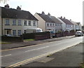
6
The Highway, Oakfield, Cwmbran
The Highway heads away from Oakfield Road towards East Road.
Image: © Jaggery
Taken: 15 Oct 2009
0.05 miles
7
East side of The Highway, Oakfield, Cwmbran
Houses on the east side of The Highway, viewed from the corner of Oakfield Road.
Image: © Jaggery
Taken: 27 Oct 2010
0.05 miles
8
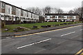
Boulder-lined grass verge, Oakfield Road, Cwmbran
Looking across Oakfield Road towards houses in Fields Road.
The long line of boulders prevents vehicular incursion onto the grass.
Image: © Jaggery
Taken: 9 Mar 2013
0.05 miles
9
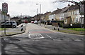
Junction of The Highway and Oakfield Road, Oakfield, Cwmbran
The 30mph speed limit on Oakfield Road drops to 20mph on The Highway. PARTH is Welsh for ZONE.
Image: © Jaggery
Taken: 23 Mar 2018
0.06 miles
10
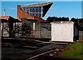
Electricity substation at the edge of Cwmbran Stadium
The Western Power Distribution electricity substation identifier is
OAKFIELD RD CWMBRAN S/S No. 532241.
Image: © Jaggery
Taken: 7 Dec 2014
0.06 miles