IMAGES TAKEN NEAR TO
Cwrt Celyn, CWMBRAN, NP44 3FA
Introduction
This page details the photographs taken nearby to Cwrt Celyn, NP44 3FA by members of the Geograph project.
The Geograph project started in 2005 with the aim of publishing, organising and preserving representative images for every square kilometre of Great Britain, Ireland and the Isle of Man.

There are currently over 7.5m images from over14,400 individuals and you can help contribute to the project by visiting https://www.geograph.org.uk
Image Map
Images are licensed for reuse under creativecommons.org/licenses/by-sa/2.0
Notes
- Clicking on the map will re-center to the selected point.
- The higher the marker number, the further away the image location is from the centre of the postcode.
Image Listing (73 Images Found)
Images are licensed for reuse under creativecommons.org/licenses/by-sa/2.0
Image
Details
Distance
1
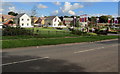
Parc Celyn houses, Cwmbran
Recently-built Taylor Wimpey houses set back from Greenmeadow Way on part
of the site previously occupied by a police training centre, viewed on October 10th 2016.
Image: © Jaggery
Taken: 10 Oct 2016
0.01 miles
2
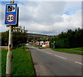
Greenmeadow Way bus stop, Cwmbran
In October 2016, this stop for buses to the town centre and Cwmbran bus station is part of Stagecoach Route 5 and Route 6. Beyond Greenmeadow Way each follows a different route to the bus station.
Image: © Jaggery
Taken: 10 Oct 2016
0.06 miles
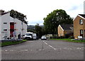
3
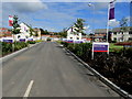
Cwrt Celyn, Parc Celyn, Cwmbran
Cwrt Celyn is a road from Greenmeadow Way into Parc Celyn, recently-built Taylor Wimpey houses
on part of the site previously occupied by a police training centre, viewed on October 10th 2016.
Image: © Jaggery
Taken: 10 Oct 2016
0.06 miles
4
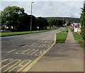
Combined speed limit and speed camera sign, Cwmbran
On a Greenmeadow Way lamppost opposite the Salisbury Court junction.
Image: © Jaggery
Taken: 20 Oct 2016
0.07 miles
5
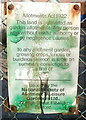
Allotments Act 1922 notice, St Dials, Cwmbran
The now faded and paint-daubed notice on the entrance gate http://www.geograph.org.uk/photo/2290586 to St Dials Allotments quotes a relevant extract from the 1922 Allotments Act relating to persons causing damage in the allotments. It shows that offenders are liable to a fine of £20 on summary conviction. No doubt later legislation has increased the penalty considerably.
In terms of average costs, £20 would be about £900 today, and in terms of average wages, about £3,500, figures which show how much more spending power the average person has today, apparently...
Image: © Jaggery
Taken: 30 Jan 2011
0.07 miles
6
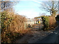
Entrance gate to St Dials allotments, Cwmbran
The entrance is from St Dials Road. This is one of twenty allotment sites in Cwmbran. Residents of Cwmbran can hire a plot (for growing vegetables or flowers) for about £20 per year. The fee includes plot rental, association fees and membership to the National Society of Allotment and Leisure Gardeners.
Image: © Jaggery
Taken: 30 Jan 2011
0.07 miles
7
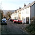
Uplands Terrace, St Dials Road, Cwmbran
A row of houses adjacent to St Dials allotments.
Image: © Jaggery
Taken: 30 Jan 2011
0.08 miles
8
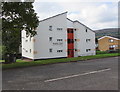
Drayton Court, St Dials, Cwmbran
Drayton Court, on the corner of Greenmeadow Way and Blenheim Road, is social housing owned by Bron Afon Housing Association. In view are numbers 1-6 Drayton Court.
Image: © Jaggery
Taken: 20 Oct 2016
0.09 miles
9
Junction of Blenheim Road and Greenmeadow Way, St Dials, Cwmbran
Blenheim Road descends from Greenmeadow Way. Drayton Court flats are on the left.
Image: © Jaggery
Taken: 20 Oct 2016
0.09 miles
10
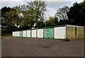
Ten lockup garages, St Dials, Cwmbran
Greenmeadow Way is behind the row of garages.
Image: © Jaggery
Taken: 20 Oct 2016
0.09 miles