IMAGES TAKEN NEAR TO
Canberra Close, CWMBRAN, NP44 3ET
Introduction
This page details the photographs taken nearby to Canberra Close, NP44 3ET by members of the Geograph project.
The Geograph project started in 2005 with the aim of publishing, organising and preserving representative images for every square kilometre of Great Britain, Ireland and the Isle of Man.

There are currently over 7.5m images from over14,400 individuals and you can help contribute to the project by visiting https://www.geograph.org.uk
Image Map
Images are licensed for reuse under creativecommons.org/licenses/by-sa/2.0
Notes
- Clicking on the map will re-center to the selected point.
- The higher the marker number, the further away the image location is from the centre of the postcode.
Image Listing (109 Images Found)
Images are licensed for reuse under creativecommons.org/licenses/by-sa/2.0
Image
Details
Distance
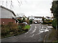
1
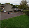
Side road to Melbourne Court and Canberra Close, Cwmbran
Descending from Greenmeadow Way.
Image: © Jaggery
Taken: 20 Oct 2016
0.04 miles
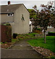
2
Path between houses, St Dials, Cwmbran
Between houses in Greenmeadow Way (on the left) and Melbourne Court.
Image: © Jaggery
Taken: 20 Oct 2016
0.05 miles
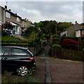
3
Steps down to Melbourne Court, Cwmbran
Descending from Greenmeadow Way.
Image: © Jaggery
Taken: 20 Oct 2016
0.05 miles
4
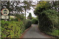
Pen-y-waun Road, Cwmbran
Pen-y-waun Road descends from Greenmeadow Way. No motor vehicles except for access.
Image: © Jaggery
Taken: 20 Oct 2016
0.06 miles
5
Ordnance Survey Cut Mark
This OS cut mark can be found on Ardath, Penywauh Road. It marks a point 87.084m above mean sea level.
Image: © Adrian Dust
Taken: 10 Sep 2020
0.06 miles
6
Pen-y-Waun Close, Cwmbran
Viewed from near the junction with Hill Top.
Image: © Jaggery
Taken: 31 Dec 2009
0.07 miles
7
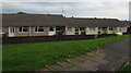
Greenmeadow Way bungalows, St Dials, Cwmbran
Originally, bungalow was used in English for a lightly-built house, with a veranda and one storey.
In current UK usage it is a convenient word for any one-storey dwelling.
Image: © Jaggery
Taken: 20 Oct 2016
0.07 miles
8
Hill Top, Cwmbran
Looking southwestwards along Hill Top from the Yew Tree Terrace turning.
Image: © Jaggery
Taken: 31 Dec 2009
0.08 miles
9
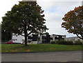
Autumn colours, Greenmeadow Way, St Dials, Cwmbran
Viewed on October 20th 2016.
Image: © Jaggery
Taken: 20 Oct 2016
0.08 miles
10
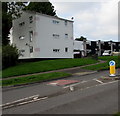
Lysted House, Greenmeadow Way, St Dials, Cwmbran
Flats owned by Bron Afon Community Housing Association.
Image: © Jaggery
Taken: 20 Oct 2016
0.08 miles