IMAGES TAKEN NEAR TO
South Road, CWMBRAN, NP44 3EL
Introduction
This page details the photographs taken nearby to South Road, NP44 3EL by members of the Geograph project.
The Geograph project started in 2005 with the aim of publishing, organising and preserving representative images for every square kilometre of Great Britain, Ireland and the Isle of Man.

There are currently over 7.5m images from over14,400 individuals and you can help contribute to the project by visiting https://www.geograph.org.uk
Image Map
Images are licensed for reuse under creativecommons.org/licenses/by-sa/2.0
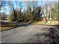
Notes
- Clicking on the map will re-center to the selected point.
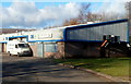
- The higher the marker number, the further away the image location is from the centre of the postcode.
Image Listing (133 Images Found)
Images are licensed for reuse under creativecommons.org/licenses/by-sa/2.0
Image
Details
Distance
1
Fields Road, Cwmbran
The view westwards along Fields Road from the corner of Green Willows.
Image: © Jaggery
Taken: 30 Jul 2010
0.03 miles
2
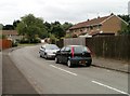
Plas Ty-coch, Cwmbran
The northern side of a cul-de-sac, viewed from Fields Road.
Image: © Jaggery
Taken: 30 Jul 2010
0.03 miles
3
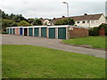
Garages, Fields Road, Cwmbran
A row of 11 lock-up garages occupies part of a small green space on the south side of Fields Road. There are similar garages facing them, just out of shot on the left.
The text of a faded, or more likely vandalised, notice on the wall of the garages is now incomplete.
It probably once read
BOROUGH OF TORFAEN
NO BALL GAMES ALLOWED
BY ORDER
Image: © Jaggery
Taken: 30 Jul 2010
0.03 miles
4
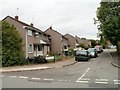
Abbey Green, Cwmbran
A cul-de-sac on the north side of Fields Road.
Image: © Jaggery
Taken: 30 Jul 2010
0.04 miles
5
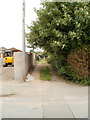
Path north from Fields Road, Cwmbran
A path - or is it a track ? - heads away from the north side of Fields Road. It ends at East Road, about 200 metres away.
Image: © Jaggery
Taken: 30 Jul 2010
0.04 miles
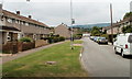
6
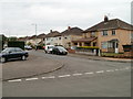
Corner of South Road and Fields Road, Cwmbran
Houses on the east side of South Road, near the corner of Fields Road.
Image: © Jaggery
Taken: 30 Jul 2010
0.04 miles
7
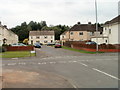
The southern end of South Road, Cwmbran
South Road began about 200 metres behind the camera. Its final 60 metres or so is ahead, on the far side of Fields Road.
Image: © Jaggery
Taken: 30 Jul 2010
0.05 miles
8
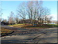
Trees at a junction in John Baker Close, Llantarnam Park
John Baker Close is the main road through Llantarnam Park.
Left- and right-pointing arrows on a sign direct visitors to various business premises.
Image: © Jaggery
Taken: 1 Dec 2012
0.08 miles
9
A bend in John Baker Close, Llantarnam
John Baker Close is the main road through Llantarnam Park.
The trees are on the south bank of Dowlais Brook, a tributary of the Afon Lwyd.
Image: © Jaggery
Taken: 1 Dec 2012
0.08 miles
10
Mark's Meats premises and van, Llantarnam Park, Cwmbran
Caterting and wholesale butcher located in Unit 36, Llantarnam Park.
Image: © Jaggery
Taken: 1 Dec 2012
0.09 miles