IMAGES TAKEN NEAR TO
Poppy Field Avenue, CWMBRAN, NP44 3DD
Introduction
This page details the photographs taken nearby to Poppy Field Avenue, NP44 3DD by members of the Geograph project.
The Geograph project started in 2005 with the aim of publishing, organising and preserving representative images for every square kilometre of Great Britain, Ireland and the Isle of Man.

There are currently over 7.5m images from over14,400 individuals and you can help contribute to the project by visiting https://www.geograph.org.uk
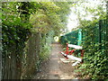
Image Map
Images are licensed for reuse under creativecommons.org/licenses/by-sa/2.0
Notes
- Clicking on the map will re-center to the selected point.
- The higher the marker number, the further away the image location is from the centre of the postcode.
Image Listing (179 Images Found)
Images are licensed for reuse under creativecommons.org/licenses/by-sa/2.0
Image
Details
Distance
1

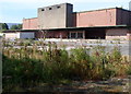
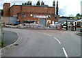
Building demolition on the Abbey Park site, Cwmbran
At the end of April 2014, work was in progress on clearing a brownfield site for the construction of the David Wilson Homes Abbey Park development. Here, a former factory building is being demolished.
Image: © Jaggery
Taken: 30 Apr 2014
0.01 miles
2
Derelict former cold stores, Llantarnam, Cwmbran
The derelict site is located on the east side of Llantarnam Road.
Also on the site, out of shot on the left, are five disused Nissen huts. http://www.geograph.org.uk/photo/2536434
A Notice of Application for Planning Permission dated July 27 2012 is attached to a fence alongside the footpath from where this view was taken. The notice states that Barratt Homes (South Wales) is applying to Torfaen County Borough Council for planning permission to demolish the existing buildings and erect 64 houses.
Image: © Jaggery
Taken: 6 Sep 2012
0.03 miles
3
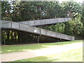
Cwmbran Boating Lake side of a railway footbridge
A double flight of steps from the boating lake site lead up to a footbridge to paths on the far side of the Welsh Marches railway line.
Image: © Jaggery
Taken: 3 Aug 2011
0.03 miles
4
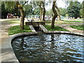
Inlet from the Afon Lwyd, Cwmbran Boating Lake
The main boating lake is in the SE section of the site, behind the camera. It measures about 250 metres long and 100 metres wide (at the widest point). In the NW section of the site are a children's play area, glimpsed in the background here, and two connected small ponds, each about 35 metres long and a few metres across. At their NW edge, there is an inlet, seen here, supplying a constant inflow of water from the Afon Lwyd. A corresponding outlet, at the opposite end of the two small ponds, returns excess water to the Afon Lwyd.
Image: © Jaggery
Taken: 3 Aug 2011
0.04 miles
5
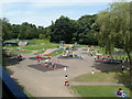
Children's play area, Cwmbran Boating Lake
Viewed from the steps http://www.geograph.org.uk/photo/2537547 to a railway footbridge. The play area is in the north of the site.
Image: © Jaggery
Taken: 3 Aug 2011
0.04 miles
6
Path NW to Court Road Industrial Estate, Cwmbran
Viewed from the edge of a footbridge from the Cwmbran Boating Lake site. The path runs parallel with the Welsh Marches railway line. http://www.geograph.org.uk/photo/2537605 The green railway fence is on the right.
Image: © Jaggery
Taken: 3 Aug 2011
0.04 miles
7
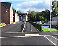
Poppy Field Avenue houses, Llantarnam, Cwmbran
Recently-built houses viewed past the corner of Poplar Place in September 2016.
Image: © Jaggery
Taken: 22 Sep 2016
0.04 miles
8
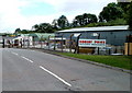
Southern part of Robert Price premises, Court Road Industrial Estate
Robert Price, builders' merchant, occupies a large site in the SE section of Court Road Industrial Estate. The part of the site seen here includes several green Nissen huts.
Image: © Jaggery
Taken: 7 Aug 2010
0.05 miles
9
Central section of Robert Price premises, Court Road Industrial Estate, Cwmbran
Robert Price, builders' merchant, occupies a large site in the SE section of Court Road Industrial Estate. Seen here is the central section of the site.
Image: © Jaggery
Taken: 7 Aug 2010
0.05 miles
10
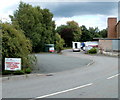
Car park entrance, Robert Price, Court Road Industrial Estate
Robert Price, builders' merchant, occupies a large site http://www.geograph.org.uk/photo/2075972 http://www.geograph.org.uk/photo/2075983 in the SE of Court Road Industrial Estate. The entrance to their car park is on the northern edge of the premises.
Image: © Jaggery
Taken: 7 Aug 2010
0.05 miles