IMAGES TAKEN NEAR TO
Llantarnam Road, CWMBRAN, NP44 3BJ
Introduction
This page details the photographs taken nearby to Llantarnam Road, NP44 3BJ by members of the Geograph project.
The Geograph project started in 2005 with the aim of publishing, organising and preserving representative images for every square kilometre of Great Britain, Ireland and the Isle of Man.

There are currently over 7.5m images from over14,400 individuals and you can help contribute to the project by visiting https://www.geograph.org.uk
Image Map
Images are licensed for reuse under creativecommons.org/licenses/by-sa/2.0
Notes
- Clicking on the map will re-center to the selected point.
- The higher the marker number, the further away the image location is from the centre of the postcode.
Image Listing (198 Images Found)
Images are licensed for reuse under creativecommons.org/licenses/by-sa/2.0
Image
Details
Distance
1
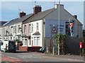
Bill poster, Cwmbran
Clad in an orange dayglo jacket, a bill poster is on a ladder
at the end of a row of houses in Llantarnam Road.
Image: © Jaggery
Taken: 6 Sep 2012
0.01 miles
2
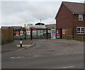
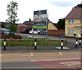
Barratt Homes building site entrance, Llantarnam, Cwmbran
Viewed across Llantarnam Road in early August 2018. New houses
are being built on the site of the demolished Llantarnam Comprehensive school.
Image: © Jaggery
Taken: 4 Aug 2018
0.01 miles
3
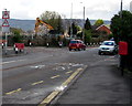
Warning signs, Llantarnam Road, Cwmbran
The red-edged triangular signs show that the road narrows at a pedestrian crossing 75 yards ahead.
The CAUTION SITE ENTRANCE temporary sign is on the approach to the entrance to
the building site in the grounds of the demolished former Llantarnam Comprehensive School.
Image: © Jaggery
Taken: 31 Mar 2017
0.02 miles
4
Queen Elizabeth II postbox, Llantarnam, Cwmbran
On the right here. http://www.geograph.org.uk/photo/3117478
Image: © Jaggery
Taken: 22 Sep 2016
0.02 miles
5
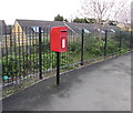
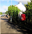
Queen Elizabeth II postbox alongside Llantarnam Road railings, Cwmbran
Located on the right here. http://www.geograph.org.uk/photo/5330974
The manufacturer's name embossed on the bottom of the box is MACHAN SCOTLAND.
Image: © Jaggery
Taken: 31 Mar 2017
0.02 miles
6
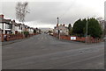
SE end of Llantarnam Road, Cwmbran
Llantarnam Road heads away from Newport Road, towards Llantarnam and central Cwmbran.
Image: © Jaggery
Taken: 3 Jan 2013
0.02 miles
7
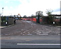
Llantarnam Road entrance to a building site, Cwmbran
Viewed on March 31st 2017. See http://www.geograph.org.uk/photo/5330964 for another view of the building site and some details.
Image: © Jaggery
Taken: 31 Mar 2017
0.02 miles
8
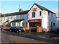
Curry Box, Llantarnam, Cwmbran
Llantarnam Road Indian cuisine takeaway located opposite Llantarnam School.
The "The" has been omitted from the new nameboard. Compare with this view http://www.geograph.org.uk/photo/1999755 taken in February 2010.
Image: © Jaggery
Taken: 4 Dec 2012
0.03 miles
9
Welcome to St Michael's Gate, Llantarnam, Cwmbran
The Barratt Homes sign faces Llantarnam Road on the corner of James Prosser Way, viewed in August 2018.
The housing development is on the site of the demolished Llantarnam Comprehensive School.
Image: © Jaggery
Taken: 4 Aug 2018
0.03 miles
10
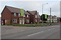
St Michael's Gate houses, Llantarnam, Cwmbran
Part of the Barratt Homes development on the site of the demolished
Llantarnam Comprehensive School viewed across Llantarnam Road in early August 2018.
Image: © Jaggery
Taken: 4 Aug 2018
0.03 miles