IMAGES TAKEN NEAR TO
Ty Coch Lane, Llantarnam Park Way, CWMBRAN, NP44 3AU
Introduction
This page details the photographs taken nearby to Ty Coch Lane, Llantarnam Park Way, NP44 3AU by members of the Geograph project.
The Geograph project started in 2005 with the aim of publishing, organising and preserving representative images for every square kilometre of Great Britain, Ireland and the Isle of Man.

There are currently over 7.5m images from over14,400 individuals and you can help contribute to the project by visiting https://www.geograph.org.uk
Image Map
Images are licensed for reuse under creativecommons.org/licenses/by-sa/2.0
Notes
- Clicking on the map will re-center to the selected point.
- The higher the marker number, the further away the image location is from the centre of the postcode.
Image Listing (105 Images Found)
Images are licensed for reuse under creativecommons.org/licenses/by-sa/2.0
Image
Details
Distance
1
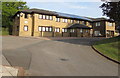
Pembroke House, Llantarnam, Cwmbran
Business centre with serviced offices viewed from the corner of Ty Coch Lane in April 2020.
Image: © Jaggery
Taken: 23 Apr 2020
0.00 miles
2
Pembroke House, Llantarnam
Located on the corner of Cwmbran Drive, Llantarnam Park Way and Ty Coch Lane, Pembroke House is a 2-storey office building completed in 1990, originally as headquarters for a local property developer.
It is now operated by Pembroke House Limited as Executive Serviced Offices. The original building has been extended by 4,000 square feet increasing the number of office suites from 15 to 27.
Image: © Jaggery
Taken: 1 Dec 2012
0.00 miles
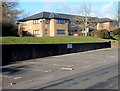
3

Three name signs on a bank above Llantarnam Park Way, Cwmbran
Names in view in April 2020 are Pembroke House (part of which is in the background), Green & Co accountants and tax advisors and Parkway Hotel and Spa.
Image: © Jaggery
Taken: 23 Apr 2020
0.02 miles
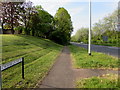
4
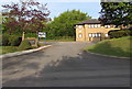
Access road to Pembroke House, Llantarnam, Cwmbran
From Ty Coch Lane to the business centre with serviced offices in Pembroke House. https://www.geograph.org.uk/photo/6451290
Image: © Jaggery
Taken: 23 Apr 2020
0.02 miles
5
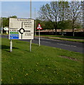
Directions sign alongside Llantarnam Park Way, Cwmbran
On the approach to the roundabout in the middle of the A4051 Cwmbran Drive.
Image: © Jaggery
Taken: 23 Apr 2020
0.02 miles
6

Wordless directions sign alongside Llantarnam Park Way, Cwmbran
On the approach to the crossroads at the A4051 Cwmbran Drive junction.
Image: © Jaggery
Taken: 23 Apr 2020
0.02 miles
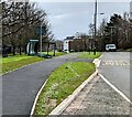
7
Pavement on the east side of the A4051 Cwmbran Drive, Llantarnam, Cwmbran
The Woodlands Roundabout at the edge of the Malpas area of Newport is about a mile (1.6km) ahead.
Image: © Jaggery
Taken: 23 Apr 2020
0.03 miles
8
Toppled bus shelter, Llantarnam Park Way, Cwmbran
Viewed on February 21st 2022. The shelter toppled over after being buffeted by three named storms in the previous few days - Dudley, Eunice and Franklin.
Image: © Jaggery
Taken: 21 Feb 2022
0.03 miles
9
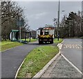
Torfaen Council lorry, Llantarnam Park Way, Cwmbran
Viewed on February 21st 2022. The lorry has brought cones to cordon off a bus shelter toppled by strong gusts.
Image: © Jaggery
Taken: 21 Feb 2022
0.03 miles
10
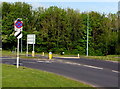
End of the 30 speed limit at the western end of Llantarnam Park Way, Cwmbran
From 30mph to the National Speed Limit on the approach to the A4051 Cwmbran Drive.
A Clearway sign is also in view.
Image: © Jaggery
Taken: 23 Apr 2020
0.03 miles