IMAGES TAKEN NEAR TO
The Manor, CWMBRAN, NP44 3AQ
Introduction
This page details the photographs taken nearby to The Manor, NP44 3AQ by members of the Geograph project.
The Geograph project started in 2005 with the aim of publishing, organising and preserving representative images for every square kilometre of Great Britain, Ireland and the Isle of Man.

There are currently over 7.5m images from over14,400 individuals and you can help contribute to the project by visiting https://www.geograph.org.uk
Image Map
Images are licensed for reuse under creativecommons.org/licenses/by-sa/2.0
Notes
- Clicking on the map will re-center to the selected point.
- The higher the marker number, the further away the image location is from the centre of the postcode.
Image Listing (276 Images Found)
Images are licensed for reuse under creativecommons.org/licenses/by-sa/2.0
Image
Details
Distance
1

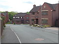
Path from Pentre Lane approaches The Manor, Llantarnam, Cwmbran
The Manor is an area of modern houses located between Cwmbran Drive and Newport Road.
Image: © Jaggery
Taken: 30 May 2013
0.01 miles
2
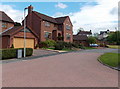
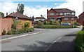
Western arm of The Manor, Llantarnam, Cwmbran
Part of the central section of The Manor, an area of modern houses located between Cwmbran Drive and Newport Road.
Image: © Jaggery
Taken: 30 May 2013
0.02 miles
3
Houses in the central section of The Manor, Llantarnam, Cwmbran
The Manor is an area of modern houses located between Cwmbran Drive and Newport Road.
The red tiled section of road is part of a slight bump designed as a traffic calming measure.
Image: © Jaggery
Taken: 30 May 2013
0.03 miles
4
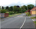
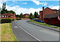
Traffic calming along The Manor, Llantarnam, Cwmbran
The Manor is an area of modern houses located between Cwmbran Drive and Newport Road.
Black and white posts, and a red tiled road surface, mark a brief narrowing the roadway.
On the left are The Manor Pumping Station http://www.geograph.org.uk/photo/3486329 and more black and white posts.
Image: © Jaggery
Taken: 30 May 2013
0.04 miles
5
The Manor Pumping Station enclosure, Llantarnam, Cwmbran
http://www.geograph.org.uk/photo/3486335 to a view inside the enclosure.
The Manor is an area of modern houses located between Cwmbran Drive and Newport Road.
Image: © Jaggery
Taken: 30 May 2013
0.04 miles
6
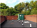
The Manor Pumping Station, Llantarnam, Cwmbran
Located inside this http://www.geograph.org.uk/photo/3486329 enclosure.
Image: © Jaggery
Taken: 30 May 2013
0.04 miles
7
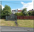
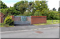
Electricity substation 532543, The Manor, Llantarnam, Cwmbran
Wooden steps lead up to the Western Power Distribution substation located in The Manor,
an area of modern houses located between Cwmbran Drive and Newport Road.
Image: © Jaggery
Taken: 30 May 2013
0.04 miles
8
Northern section of The Manor, Llantarnam, Cwmbran
The Manor is an area of modern houses located between Cwmbran Drive and Newport Road.
Image: © Jaggery
Taken: 30 May 2013
0.05 miles
9
Traffic bump 35 yards ahead, The Manor, Llantarnam, Cwmbran
The triangular sign is in The Manor, an area of modern houses located between Cwmbran Drive and Newport Road.
Image: © Jaggery
Taken: 30 May 2013
0.05 miles
10
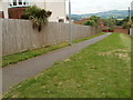
Path from Newport Road to The Manor, Llantarnam
Starting near bus stops on Newport Road, a path heads towards the eastern edge of houses on The Manor.http://www.geograph.org.uk/photo/1725573 The short cut saves pedestrians a walk of up to 400 metres.
In the middle of high ground in the far distance is the distinctive mounded peak of Twmbarlwm. Image
Image: © Jaggery
Taken: 30 Jul 2010
0.06 miles