IMAGES TAKEN NEAR TO
Newport Road, CWMBRAN, NP44 3AF
Introduction
This page details the photographs taken nearby to Newport Road, NP44 3AF by members of the Geograph project.
The Geograph project started in 2005 with the aim of publishing, organising and preserving representative images for every square kilometre of Great Britain, Ireland and the Isle of Man.

There are currently over 7.5m images from over14,400 individuals and you can help contribute to the project by visiting https://www.geograph.org.uk
Image Map
Images are licensed for reuse under creativecommons.org/licenses/by-sa/2.0
Notes
- Clicking on the map will re-center to the selected point.
- The higher the marker number, the further away the image location is from the centre of the postcode.
Image Listing (275 Images Found)
Images are licensed for reuse under creativecommons.org/licenses/by-sa/2.0
Image
Details
Distance
1
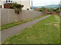
Path from Newport Road to The Manor, Llantarnam
Starting near bus stops on Newport Road, a path heads towards the eastern edge of houses on The Manor.http://www.geograph.org.uk/photo/1725573 The short cut saves pedestrians a walk of up to 400 metres.
In the middle of high ground in the far distance is the distinctive mounded peak of Twmbarlwm. Image
Image: © Jaggery
Taken: 30 Jul 2010
0.01 miles
2
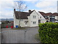
Occupational Health Unit, Newport Road, Cwmbran
Gwent Police's Occupational Health Unit is located in the Old Police House.
Image: © Jaggery
Taken: 28 Mar 2020
0.01 miles
3
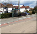
Newport Road bus stop and shelter, Llantarnam, Cwmbran
This stop for buses to Cwmbran bus station and the town centre.
Image: © Jaggery
Taken: 16 Apr 2016
0.02 miles
4
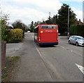
Stagecoach bus 47635 on Newport Road, Cwmbran
Travelling north on bus route 23 from Newport to Pontypool in March 2020.
Image: © Jaggery
Taken: 28 Mar 2020
0.02 miles
5
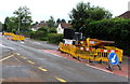
Yellow temporary barriers on Newport Road, Llantarnam, Cwmbran
On Sunday June 26th 2016, temporary traffic lights several hundred metres apart
are maintaining an alternating one-way flow of traffic past yellow roadworks barriers.
Image: © Jaggery
Taken: 26 Jun 2016
0.02 miles
6
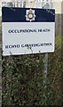
Bilingual Occupational Health board, Newport Road, Cwmbran
The board at the entrance to this https://www.geograph.org.uk/photo/6426155 Gwent Police site shows that Occupational Health is Iechyd Galwedigaethol in Welsh.
Image: © Jaggery
Taken: 28 Mar 2020
0.02 miles
7
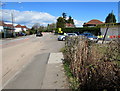
North along Newport Road, Llantarnam, Cwmbran
Brilliant Hand Car Wash is on the right.
Image: © Jaggery
Taken: 16 Apr 2016
0.02 miles
8
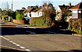
Houses and hedges, Newport Road, Llantarnam, Cwmbran
On the west side of Newport Road. The broken white line is at the Lansdowne Gardens junction.
Image: © Jaggery
Taken: 27 Feb 2021
0.02 miles
9
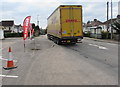
Yellow articulated lorry in Llantarnam, Cwmbran
The DHL lorry is travelling south on Newport Road in March 2020.
DHL provides courier services for parcel delivery in the UK and internationally.
Image: © Jaggery
Taken: 28 Mar 2020
0.02 miles
10
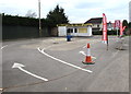
Closed Brilliant Hand Car Wash, Newport Road, Llantarnam, Cwmbran
On March 28th 2020 a chain and cone are across the entrance from Newport Road. In common with many other businesses is the UK, this car wash is closed until further notice during the Coronavirus (COVID-19) global pandemic.
Image: © Jaggery
Taken: 28 Mar 2020
0.03 miles