IMAGES TAKEN NEAR TO
Newport Road, CWMBRAN, NP44 3AE
Introduction
This page details the photographs taken nearby to Newport Road, NP44 3AE by members of the Geograph project.
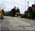
The Geograph project started in 2005 with the aim of publishing, organising and preserving representative images for every square kilometre of Great Britain, Ireland and the Isle of Man.

There are currently over 7.5m images from over14,400 individuals and you can help contribute to the project by visiting https://www.geograph.org.uk
Image Map
Images are licensed for reuse under creativecommons.org/licenses/by-sa/2.0
Notes
- Clicking on the map will re-center to the selected point.
- The higher the marker number, the further away the image location is from the centre of the postcode.
Image Listing (266 Images Found)
Images are licensed for reuse under creativecommons.org/licenses/by-sa/2.0
Image
Details
Distance
1
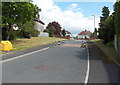
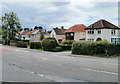
Eastern end of The Manor, Llantarnam, Cwmbran
Looking towards houses in Newport Road.
Image: © Jaggery
Taken: 30 May 2013
0.01 miles
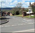
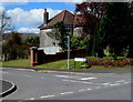
2
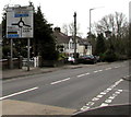
Woodlands Roundabout sign, Llantarnam
Viewed across Newport Road from the corner of The Manor. http://www.geograph.org.uk/photo/1725573 The roundabout is 150 metres ahead.
Image: © Jaggery
Taken: 28 Feb 2015
0.01 miles
3
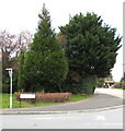
Evergreen trees on a Llantarnam corner, Cwmbran
On the corner of Newport Road and The Manor on March 28th 2020. Nearby deciduous trees are leafless.
Image: © Jaggery
Taken: 28 Mar 2020
0.02 miles
4
Pelican crossing, Newport Road, Llantarnam, Cwmbran
Chambers Dictionary states that pelican in this context is adapted from "pedestrian light controlled crossing".
Image: © Jaggery
Taken: 16 Apr 2016
0.02 miles
5
Newport Road pelican crossing, Llantarnam, Cwmbran
Across Newport Road between the Manor junction and the Lansdowne Gardens junction ahead on the right.
The red flags are at a car wash entrance.
Image: © Jaggery
Taken: 28 Mar 2020
0.02 miles
6
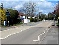
Junction of The Manor and Newport Road, Llantarnam, Cwmbran
The Manor (Y Faenor in Welsh) is an area of modern houses extending for c350 metres from Newport Road.
Image: © Jaggery
Taken: 16 Apr 2016
0.02 miles
7
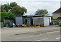
Llantarnam Service Station
Premises are now a roadside shop. In busier days, before the opening of Cwmbran Drive (A4051) to the west and the A4042 to the east, this was a petrol filling station.
UPDATE September 2012. The site is now occupied by UK Hand Car Wash. http://www.geograph.org.uk/photo/3117447
Image: © Jaggery
Taken: 25 Aug 2009
0.02 miles
8
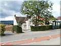
Occupational Health Unit, Llantarnam
Gwent Police's Occupational Health Unit is located at Old Police House, Newport Road, Llantarnam.
Image: © Jaggery
Taken: 7 Aug 2010
0.02 miles
9
Llantarnam : Newport Road houses adjacent to Lansdowne Gardens
Houses on the west side of Newport Road, viewed from near the turning for Lansdowne Gardens.
Image: © Jaggery
Taken: 7 Aug 2010
0.02 miles
10
Corner of The Manor and Newport Road, Llantarnam, Cwmbran
The Manor (Y Faenor in Welsh) is an area of modern houses extending for c350 metres from Newport Road.
Image: © Jaggery
Taken: 16 Apr 2016
0.03 miles