IMAGES TAKEN NEAR TO
William Brown Close, CWMBRAN, NP44 3AB
Introduction
This page details the photographs taken nearby to William Brown Close, NP44 3AB by members of the Geograph project.
The Geograph project started in 2005 with the aim of publishing, organising and preserving representative images for every square kilometre of Great Britain, Ireland and the Isle of Man.

There are currently over 7.5m images from over14,400 individuals and you can help contribute to the project by visiting https://www.geograph.org.uk
Image Map
Images are licensed for reuse under creativecommons.org/licenses/by-sa/2.0
Notes
- Clicking on the map will re-center to the selected point.
- The higher the marker number, the further away the image location is from the centre of the postcode.
Image Listing (200 Images Found)
Images are licensed for reuse under creativecommons.org/licenses/by-sa/2.0
Image
Details
Distance
1
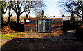
Parrot Corporation Llantarnam electricity substation in Cwmbran
The identifier on the Western Power Distribution electricity substation
in William Brown Close is PARROT CORPORATION LLANTARNAM S/S No. 532538.
Image: © Jaggery
Taken: 29 Dec 2014
0.06 miles
2
John Fielding Gardens, Llantarnam
Viewed from Newport Road. http://www.geograph.org.uk/photo/1611672 to a potted history of John Fielding VC, who is buried in the churchyard nearby.
Image: © Jaggery
Taken: 24 Feb 2010
0.06 miles
3
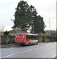
Bus timing point, Newport Road, Llantarnam
I wondered why this bus was stopped for several minutes, thinking it must have broken down. Then I realised this is a bus timing point. If a bus is early, it waits here until the appointed departure time. Many bus timetables point out that times shown for most stops (ie those not designated as timing points) are only estimates. And, of course, no timetable can take account of unexpected delays in the arrival of a bus...
Image: © Jaggery
Taken: 24 Feb 2010
0.07 miles
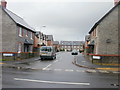
4

Walnut Grove, Llantarnam
The entrance road from Newport Road to new houses in Walnut Grove.
Image: © Jaggery
Taken: 24 Feb 2010
0.07 miles
5
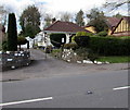
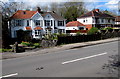
Newport Road bungalow, Llantarnam, Cwmbran
Originally, bungalow was used in English for a lightly-built house, with a veranda and one storey.
In current UK usage it is a convenient word for any one-storey dwelling.
Image: © Jaggery
Taken: 16 Apr 2016
0.07 miles
6

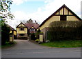
Raglan House, Llantarnam Business Park, Cwmbran
Built in the late 1980s by the Welsh Development Agency, Raglan House is 2-storey
office building on the corner of William Brown Close and Llantarnam Park Way.
Image: © Jaggery
Taken: 29 Dec 2014
0.07 miles
7
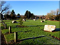
Boulders on a green in Llantarnam Business Park, Cwmbran
The green is alongside William Brown Close, viewed in late December 2014. A Google Earth Street View taken in May 2011 shows the perimeter wooden posts but no boulders. A local told me that the boulders were installed to prevent the green being used for the vehicles of Travelling People, the name by which itinerant people often call themselves, in preference to names now usually seen as derogatory, such as gypsies or tinkers.
Image: © Jaggery
Taken: 29 Dec 2014
0.07 miles
8
Newport Road semis, Llantarnam, Cwmbran
Semi-detached houses located between Llantarnam Park Way and John Fielding Gardens.
Image: © Jaggery
Taken: 16 Apr 2016
0.08 miles
9
Walnut Grove, Llantarnam, Cwmbran
21st century housing set back from Newport Road.
Image: © Jaggery
Taken: 16 Apr 2016
0.08 miles
10
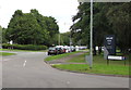
William Brown Close, Llantarnam, Cwmbran
The southern end of William Brown Close viewed from Llantarnam Park Way.
William Brown Close and Raglan House name signs are on the right.
Image: © Jaggery
Taken: 21 Aug 2018
0.08 miles