IMAGES TAKEN NEAR TO
Turnpike Road, CWMBRAN, NP44 2YB
Introduction
This page details the photographs taken nearby to Turnpike Road, NP44 2YB by members of the Geograph project.
The Geograph project started in 2005 with the aim of publishing, organising and preserving representative images for every square kilometre of Great Britain, Ireland and the Isle of Man.

There are currently over 7.5m images from over14,400 individuals and you can help contribute to the project by visiting https://www.geograph.org.uk
Image Map
Images are licensed for reuse under creativecommons.org/licenses/by-sa/2.0
Notes
- Clicking on the map will re-center to the selected point.
- The higher the marker number, the further away the image location is from the centre of the postcode.
Image Listing (99 Images Found)
Images are licensed for reuse under creativecommons.org/licenses/by-sa/2.0
Image
Details
Distance
1
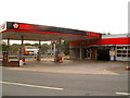
Woodland Road Service Station, Croesyceiliog, Cwmbran
Located on the corner of Woodland Road and The Highway. I don't know if the service station is temporarily closed, or has been abandoned. Three of the pumps are encased in plastic, the shop is shuttered mid-afternoon on a weekday, and there is a general appearance of dereliction.
http://www.geograph.org.uk/photo/2599147 to the view across Woodland Road.
Image: © Jaggery
Taken: 12 Sep 2011
0.03 miles
2
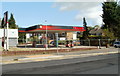
Fenced off Woodland Road Service Station, Croesyceiliog, Cwmbran
Viewed across Woodland Road. Temporary metal fencing surrounds the perimeter of the Texaco service station. I don't know if it closed for refurbishment, or has become derelict. http://www.geograph.org.uk/photo/2597394 to another view.
Image: © Jaggery
Taken: 13 Sep 2011
0.03 miles
3
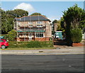
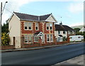
Sunny Croft scaffolding, Croesyceiliog, Cwmbran
A house on Woodland Road is undergoing building work. Its neighbour, Woodland Road Service Station, out of shot on the right, http://www.geograph.org.uk/photo/2599147 may also be in the middle of alterations, or may have become derelict.
Image: © Jaggery
Taken: 13 Sep 2011
0.03 miles
4
Woodland Road entrance to Croesyceiliog School, Cwmbran
The school website states that Croesyceiliog School is a comprehensive school for pupils and students aged 11-18 years. Under Welsh Assembly Government regulations, the school is defined as a Predominantly English Medium Secondary School. The school was created in 1971 through the merger of a grammar school (opened in 1959) with an adjacent secondary modern school (opened in 1957).
Image: © Jaggery
Taken: 15 Feb 2015
0.04 miles
5
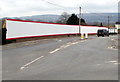
Long red and white fence, Woodland Road, Croesyceiliog, Cwmbran
Viewed in February 2018. The fence covers Croesyceiliog School perimeter railings. Behind the fence, work is in progress on the construction of new school buildings which will replace the existing buildings.
Image: © Jaggery
Taken: 27 Feb 2018
0.05 miles
6
Woodland Road entrance to Croesyceiliog School, Cwmbran
The sign on the right shows that the school name is Ysgol Croesyceiliog in Welsh.
Image: © Jaggery
Taken: 27 Feb 2018
0.06 miles
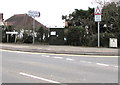
7
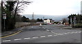
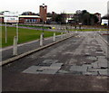
SE end of Woodland Road, Croesyceiliog, Cwmbran
At the junction of Turnpike Road to the left and The Highway to the right.
Image: © Jaggery
Taken: 15 Feb 2015
0.06 miles
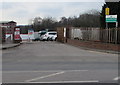
8
Woodland Road, Croesyceiliog
From the T-junction with Turnpike Road and The Highway
Image: © Jaggery
Taken: 8 Oct 2009
0.06 miles
9
House adjacent to the entrance to Croesyceiliog School, Cwmbran
Detached house on the west side of the school entrance http://www.geograph.org.uk/photo/2599082 from Woodland Road.
Image: © Jaggery
Taken: 13 Sep 2011
0.06 miles
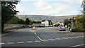
10
BT telecoms cabinet on a Croesyceiliog corner, Cwmbran
The dark green cabinet is on the corner of Woodland Road and Turnpike Road.
Image: © Jaggery
Taken: 27 Feb 2018
0.06 miles