IMAGES TAKEN NEAR TO
Raglan Court, CWMBRAN, NP44 2QR
Introduction
This page details the photographs taken nearby to Raglan Court, NP44 2QR by members of the Geograph project.
The Geograph project started in 2005 with the aim of publishing, organising and preserving representative images for every square kilometre of Great Britain, Ireland and the Isle of Man.

There are currently over 7.5m images from over14,400 individuals and you can help contribute to the project by visiting https://www.geograph.org.uk
Image Map
Images are licensed for reuse under creativecommons.org/licenses/by-sa/2.0
Notes
- Clicking on the map will re-center to the selected point.
- The higher the marker number, the further away the image location is from the centre of the postcode.
Image Listing (118 Images Found)
Images are licensed for reuse under creativecommons.org/licenses/by-sa/2.0
Image
Details
Distance
1
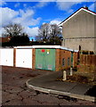
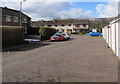
Raglan Court electricity substation, Croesyceiliog, Cwmbran
The Western Power Distribution electricity substation with a green door is at the end of a row of lockup garages. The substation identifier is RAGLAN COURT S/S 531514.
Image: © Jaggery
Taken: 7 Mar 2018
0.01 miles
2
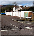
Raglan Court lockup garages, Croesyceiliog, Cwmbran
Viewed from the corner of Cardigan Crescent. The green door on the right is part of an electricity substation.
Image: © Jaggery
Taken: 7 Mar 2018
0.01 miles
3
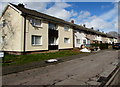
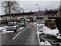
Cardigan Crescent houses, Croesyceiliog, Cwmbran
On the west side of Cardigan Crescent between Cardigan Close and Raglan Court.
Image: © Jaggery
Taken: 7 Mar 2018
0.02 miles
4
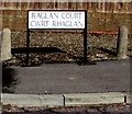
Raglan Court/Cwrt Rhaglan name sign, Croesyceiliog, Cwmbran
The English/Welsh sign is on the right here. https://www.geograph.org.uk/photo/5700221
Image: © Jaggery
Taken: 7 Mar 2018
0.02 miles
5
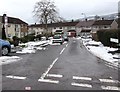
Raglan Court, Croesyceiliog, Cwmbran
Cul-de-sac on the west side of Cardigan Crescent. Lockup garages https://www.geograph.org.uk/photo/5700221 are on the right.
Image: © Jaggery
Taken: 7 Mar 2018
0.02 miles
6
Row of houses, Cardigan Crescent, Croesyceiliog, Cwmbran
The row extends for about 50 metres. Viewed from the corner of Caerwent Road.
Image: © Jaggery
Taken: 5 Mar 2018
0.02 miles
7
Cardigan Crescent, Croesyceiliog, Cwmbran
The northeast end of Cardigan Crescent viewed across Caerwent Road.
The sign on the right https://www.geograph.org.uk/photo/5698982 shows that Cardigan Crescent is Cilgant Aberteifi in Welsh.
Image: © Jaggery
Taken: 5 Mar 2018
0.05 miles
8
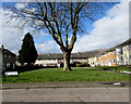
Deciduous tree, Cardigan Close, Croesyceiliog, Cwmbran
Viewed across Cardigan Crescent on March 7th 2018.
Image: © Jaggery
Taken: 7 Mar 2018
0.05 miles
9
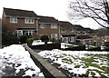
Row of houses below Caerwent Road, Croesyceiliog, Cwmbran
Viewed from near the corner of Chepstow Rise on March 5th 2018.
Patches remain from the March 1st-2nd snowfall.
Image: © Jaggery
Taken: 5 Mar 2018
0.05 miles
10
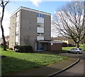
Corris House, Croesyceiliog, Cwmbran
Flats on the corner of Caerwent Road and Cardigan Crescent, on the right here https://www.geograph.org.uk/photo/5698882 next to Llanon House.
Image: © Jaggery
Taken: 7 Mar 2018
0.06 miles