IMAGES TAKEN NEAR TO
Chapel Lane, CWMBRAN, NP44 2PN
Introduction
This page details the photographs taken nearby to Chapel Lane, NP44 2PN by members of the Geograph project.
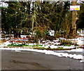
The Geograph project started in 2005 with the aim of publishing, organising and preserving representative images for every square kilometre of Great Britain, Ireland and the Isle of Man.

There are currently over 7.5m images from over14,400 individuals and you can help contribute to the project by visiting https://www.geograph.org.uk
Image Map
Images are licensed for reuse under creativecommons.org/licenses/by-sa/2.0
Notes
- Clicking on the map will re-center to the selected point.
- The higher the marker number, the further away the image location is from the centre of the postcode.
Image Listing (68 Images Found)
Images are licensed for reuse under creativecommons.org/licenses/by-sa/2.0
Image
Details
Distance
1
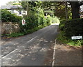
No footway for 400 yards ahead, Chapel Lane, Cwmbran
Viewed from the corner of the lane http://www.geograph.org.uk/photo/3089554 to Caerwent Road.
Image: © Jaggery
Taken: 18 Aug 2012
0.01 miles
2
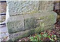
Ordnance Survey Cut Mark
This OS cut mark can be found on the gatepost of Pontrhydyrn House. It marks a point 78.837m above mean sea level.
Image: © Adrian Dust
Taken: 16 Feb 2021
0.01 miles
3
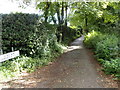
Lane from Chapel Lane to Caerwent Road houses, Cwmbran
A short lane leads to numbers 72-80 Caerwent Road.
Image: © Jaggery
Taken: 18 Aug 2012
0.02 miles
4
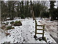
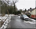
Snowy path beyond the northern end of Caerwent Road, Croesyceiliog, Cwmbran
Viewed on March 5th 2018. Roadway on the right side of the fence, path on the left side.
Image: © Jaggery
Taken: 5 Mar 2018
0.05 miles
5
Northern end of Caerwent Road, Croesyceiliog, Cwmbran
A turning area https://www.geograph.org.uk/photo/5698907 is behind the camera.
Image: © Jaggery
Taken: 5 Mar 2018
0.06 miles
6
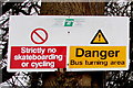
Notices on a tree near the bus turning area, Caerwent Road, Croesyceiliog, Cwmbran
On the right here. https://www.geograph.org.uk/photo/5698942
Image: © Jaggery
Taken: 5 Mar 2018
0.07 miles
7
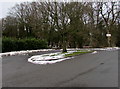
Bus turning area at the northern end of Caerwent Road, Croesyceiliog, Cwmbran
Stagecoach buses on Route 2 from Cwmbran bus station to Croesyceiliog turn around here for the return journey to the bus station. https://www.geograph.org.uk/photo/5698917 to the notices on the tree on the right.
Image: © Jaggery
Taken: 5 Mar 2018
0.07 miles
8
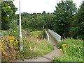
Footbridge over the Afon Lwyd, Chapel Lane, Cwmbran
The footbridge is alongside a narrow road bridge. http://www.geograph.org.uk/photo/3089416
Image: © Jaggery
Taken: 18 Aug 2012
0.08 miles
9
Rusty bench at the edge of the turning area, Caerwent Road, Croesyceiliog, Cwmbran
On the right here. https://www.geograph.org.uk/photo/5698907
Image: © Jaggery
Taken: 5 Mar 2018
0.08 miles
10
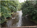
Afon Lwyd downstream from Chapel Lane, Cwmbran
Viewed from this http://www.geograph.org.uk/photo/3089424 footbridge.
Image: © Jaggery
Taken: 18 Aug 2012
0.08 miles