IMAGES TAKEN NEAR TO
Hazel Walk, CWMBRAN, NP44 2NW
Introduction
This page details the photographs taken nearby to Hazel Walk, NP44 2NW by members of the Geograph project.
The Geograph project started in 2005 with the aim of publishing, organising and preserving representative images for every square kilometre of Great Britain, Ireland and the Isle of Man.

There are currently over 7.5m images from over14,400 individuals and you can help contribute to the project by visiting https://www.geograph.org.uk
Image Map
Images are licensed for reuse under creativecommons.org/licenses/by-sa/2.0
Notes
- Clicking on the map will re-center to the selected point.
- The higher the marker number, the further away the image location is from the centre of the postcode.
Image Listing (99 Images Found)
Images are licensed for reuse under creativecommons.org/licenses/by-sa/2.0
Image
Details
Distance
1
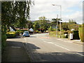
Chapel Lane, Croesyceiliog
Looking along Chapel Lane from the junction of The Highway and Newport Road. On the left is the turning for Cefn Close.
Image: © Jaggery
Taken: 8 Oct 2009
0.04 miles
2
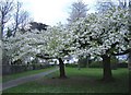
Cherry trees in full blossom.
In Holly Lodge Road, Croesyceiliog.
Image: © Roger Cornfoot
Taken: 11 Apr 2007
0.04 miles
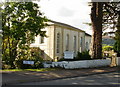
3
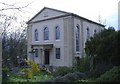
Evangelical Baptist Chapel, Croesyceiliog
Built in 1836.
Image: © Roger Cornfoot
Taken: 11 Apr 2007
0.04 miles
4
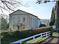
Croesyceiliog Evangelical Baptist Church
Image: © Ruth Sharville
Taken: 12 Mar 2012
0.06 miles
5
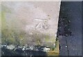
Ordnance Survey Cut Mark
This OS cut mark can be found on the east angle of the chapel. It marks a point 105.183m above mean sea level.
Image: © Adrian Dust
Taken: 16 Feb 2021
0.06 miles
6
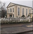
Grade II Listed Pontrhydyrun Baptist Church, Cwmbran
Grade II Listed in 1951 as "a particularly fine classical
chapel of 1836, of unusual size and with good ashlar detail".
Image: © Jaggery
Taken: 24 Dec 2023
0.07 miles
7
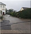
Access road to Pontrhydyrun Baptist Church (Evangelical), Ciwmbran
Dead-end road viewed from Chapel Lane.
Image: © Jaggery
Taken: 24 Dec 2023
0.07 miles
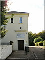
8
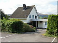
Pontrhydyrun Baptist Church manse
The manse is adjacent to the church. http://www.geograph.org.uk/photo/1526128
Image: © Jaggery
Taken: 8 Oct 2009
0.07 miles
9
Pontrhydyrun Baptist Church, NE entrance
The inscription on the black roundel located above the name of the church reads "George Conway and family founded this church in 1807".
The Conway family were tinplate manufacturers.
Image: © Jaggery
Taken: 8 Oct 2009
0.07 miles
10
Pontrhydyrun Baptist Church
Viewed from Chapel Lane. The date on the building (here obscured by a tree) is 1836. The date of the founding of the church (presumably a temporary structure) shown on a roundel on another part of the church http://www.geograph.org.uk/photo/1526151 is 1807.
Image: © Jaggery
Taken: 8 Oct 2009
0.07 miles