IMAGES TAKEN NEAR TO
Edlogan Way, CWMBRAN, NP44 2LT
Introduction
This page details the photographs taken nearby to Edlogan Way, NP44 2LT by members of the Geograph project.
The Geograph project started in 2005 with the aim of publishing, organising and preserving representative images for every square kilometre of Great Britain, Ireland and the Isle of Man.

There are currently over 7.5m images from over14,400 individuals and you can help contribute to the project by visiting https://www.geograph.org.uk
Image Map
Images are licensed for reuse under creativecommons.org/licenses/by-sa/2.0
Notes
- Clicking on the map will re-center to the selected point.
- The higher the marker number, the further away the image location is from the centre of the postcode.
Image Listing (207 Images Found)
Images are licensed for reuse under creativecommons.org/licenses/by-sa/2.0
Image
Details
Distance
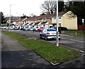
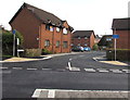
1
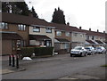
Edlogan Way houses, Croesyceiliog, Cwmbran
The three posts on the left are at the edge of a traffic calming narrowing of the roadway to one lane.
Image: © Jaggery
Taken: 7 Mar 2018
0.00 miles
2
Shelterless bus stop, Edlogan Way, Croesyceiliog, Cwmbran
This stop is for buses to Cwmbran bus station.
Image: © Jaggery
Taken: 7 Mar 2018
0.02 miles
3
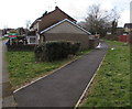
Path on the southwest side of Edlogan Way, Croesyceiliog, Cwmbran
From Edlogan Way towards Conway Terrace.
Image: © Jaggery
Taken: 7 Mar 2018
0.03 miles
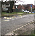
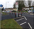
4
Traffic calming sign, Edlogan Way, Croesyceiliog, Cwmbran
Facing northbound vehicles which have priority through the narrowing of the roadway to one lane.
The text is also in Welsh.
Image: © Jaggery
Taken: 7 Mar 2018
0.04 miles
5
Edlogan Way houses, Croesyceiliog, Cwmbran
On the east side of the road. The distant houses are near Ynys Lane.
Image: © Jaggery
Taken: 15 Feb 2015
0.04 miles
6
Edlogan Way traffic calming, Croesyceiliog, Cwmbran
Traffic heading towards the camera has priority over vehicles on this side of the roadway narrowing.
Image: © Jaggery
Taken: 15 Feb 2015
0.04 miles
7
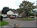
Tree at the corner of Ynys Lane and Fields View Road, Croesyceiliog, Cwmbran
Viewed from Ynys Lane. A street name sign on the white house shows Fields View Road whereas various maps have either Field View Road or Field View.
Image: © Jaggery
Taken: 27 Sep 2011
0.05 miles
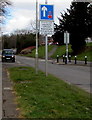
8
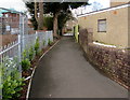
Path on the northwest side of Edlogan Way, Croesyceiliog, Cwmbran
From Edlogan Way towards Stonebridge Park.
Image: © Jaggery
Taken: 7 Mar 2018
0.05 miles
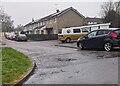
9
The Willows, Croesyceiliog, Cwmbran
Cul-de-sac on the SE side of Edlogan Way.
Image: © Jaggery
Taken: 15 Feb 2015
0.06 miles
10
Fields View Road, Croesyceiliog, Cwmbran
Looking to the NNW along Fields View Road from the road named Bryn Eglwys.
Image: © Jaggery
Taken: 24 Dec 2023
0.06 miles