1
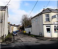
Conway Terrace, Cwmbran
Cul-de-sac viewed across Afon Terrace. Canine Corner http://www.geograph.org.uk/photo/4548731 is on the right.
Image: © Jaggery
Taken: 15 Feb 2015
0.01 miles
2
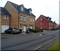
Conway Terrace, Cwmbran
Conway Terrace is a short cul-de-sac. This view is from the far end looking towards Afon Terrace.
Image: © Jaggery
Taken: 12 Dec 2012
0.03 miles
3
Get your rock salt here, Cwmbran
Viewed along Station Road looking towards Afon Terrace houses on the opposite bank of the Afon Lwyd. Various notices are for businesses located along the unnamed road on the left. The rock salt notice is for Travis Perkins.
Image: © Jaggery
Taken: 12 Dec 2012
0.03 miles
4
Afon Terrace, Cwmbran
Viewed from the Edlogan Way side. There are houses on only one side of Afon Terrace.
The opposite side is the perimeter of allotments on the bank of a river, the Afon Lwyd.
Image: © Jaggery
Taken: 12 Dec 2012
0.03 miles
5
Canine Corner, Croesyceiliog, Cwmbran
Dog grooming and pet supplies business on the corner of Afon Terrace and Conway Terrace.
Image: © Jaggery
Taken: 15 Feb 2015
0.03 miles
6
Houses on the east side of Stonebridge Park, Cwmbran
Viewed looking in the direction of the junction with Afon Terrace and Station Road. Stonebridge Park is a cul-de-sac of about 60 houses built in c2006-2007 on the east bank of a river, the Afon Lwyd.
Image: © Jaggery
Taken: 12 Dec 2012
0.04 miles
7
Bronllys Place, Croesyceiliog, Cwmbran
Viewed from the corner of Edlogan Way. The name sign shows that Bronllys Place is Maes Bronllys in Welsh.
Image: © Jaggery
Taken: 7 Mar 2018
0.04 miles
8
Station Road river bridge, Cwmbran
The bridge carries Station Road over the Afon Lwyd. On the far side of the bridge, the road is named Afon Terrace. The houses behind the trees are in Stonebridge Park.
Image: © Jaggery
Taken: 12 Dec 2012
0.04 miles
9
Ordnance Survey Cut Mark
This OS cut mark can be found on the NE parapet of the bridge. It marks a point 63.770m above mean sea level.
Image: © Adrian Dust
Taken: 16 Feb 2021
0.05 miles
10
Bronllys Place, Croesyceiliog, Cwmbran
On the west side of Edlogan Way.
Image: © Jaggery
Taken: 15 Feb 2015
0.05 miles


