IMAGES TAKEN NEAR TO
Edlogan Way, CWMBRAN, NP44 2JJ
Introduction
This page details the photographs taken nearby to Edlogan Way, NP44 2JJ by members of the Geograph project.
The Geograph project started in 2005 with the aim of publishing, organising and preserving representative images for every square kilometre of Great Britain, Ireland and the Isle of Man.

There are currently over 7.5m images from over14,400 individuals and you can help contribute to the project by visiting https://www.geograph.org.uk
Image Map
Images are licensed for reuse under creativecommons.org/licenses/by-sa/2.0
Notes
- Clicking on the map will re-center to the selected point.
- The higher the marker number, the further away the image location is from the centre of the postcode.
Image Listing (249 Images Found)
Images are licensed for reuse under creativecommons.org/licenses/by-sa/2.0
Image
Details
Distance
1
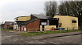
Ell Beautique in Croesyceiliog, Cwmbran
Beauty salon located between Edlogan Way and a river, the Afon Lwyd.
Image: © Jaggery
Taken: 15 Feb 2015
0.00 miles
2
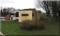
Goodes Fitness & Sports Centre, Croesyceiliog, Cwmbran
Viewed from Edlogan Way.
Image: © Jaggery
Taken: 15 Feb 2015
0.01 miles
3
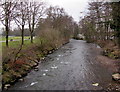
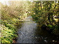
Afon Lwyd downstream from a footbridge, Croesyceiliog, Cwmbran
Viewed from this footbridge. http://www.geograph.org.uk/photo/4457557
The Afon Lwyd is a major tributary of the River Usk, into which it flows at Caerleon.
Image: © Jaggery
Taken: 15 Feb 2015
0.03 miles
4
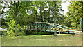
Afon Lwyd footbridge, Croesyceiliog
The footbridge crosses the Afon Lwyd (Grey River) from a recreation area to the
Edlogan Way side.
Image: © Jaggery
Taken: 8 Oct 2009
0.04 miles
5
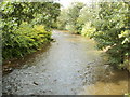
Afon Lwyd, Croesyceiliog
The Afon Lwyd heading southeast from Edlogan Way.
Image: © Jaggery
Taken: 8 Oct 2009
0.04 miles
6
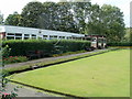
Bowling green pavilion, Croesyceiliog, Cwmbran
Part of the sports facilities available at Woodland Road Sports and Social Centre Croesyceiliog.
Image: © Jaggery
Taken: 12 Sep 2011
0.04 miles
7
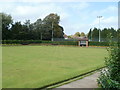
Bowls scoreboard, Croesyceiliog, Cwmbran
Looking across the bowling green towards the slate scoreboard in a brick frame.
The bowling green is part of Woodland Road Sports and Social Centre.
Image: © Jaggery
Taken: 12 Sep 2011
0.04 miles
8
Afon Lwyd, Croesyceiliog
The river flows towards this http://www.geograph.org.uk/photo/1527554 footbridge.
Image: © Jaggery
Taken: 12 Sep 2011
0.04 miles
9
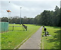
Recreation area footpath, Croesyceiliog, Cwmbran
The footpath runs along the western edge of Woodland Road Sports and Social Centre. The trees on the right are on the bank of the Afon Lwyd river. The brown object, upper left, is a dead leaf whizzing by on a gusty day caused by an Atlantic low pressure system that was formerly Hurricane Katia.
Image: © Jaggery
Taken: 12 Sep 2011
0.04 miles
10
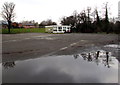
Reflections in a large puddle, Croesyceiliog, Cwmbran
Between a path http://www.geograph.org.uk/photo/4457596 and Edlogan Way.
Image: © Jaggery
Taken: 15 Feb 2015
0.04 miles